You are here: Home > Network List > AV - Alaska Volcano Observatory Stations List
> Station SPCG Capps Glacier, Mount Spurr, Alaska > Earthquake Result Viewer
SPCG Capps Glacier, Mount Spurr, Alaska - Earthquake Result Viewer
| Earthquake location: |
Kuril Islands |
| Earthquake latitude/longitude: |
44.1/149.2 |
| Earthquake time(UTC): |
2022/07/29 (210) 16:39:16 GMT |
| Earthquake Depth: |
10 km |
| Earthquake Magnitude: |
5.1 Mww |
| Earthquake Catalog/Contributor: |
NEIC PDE/us |
|
| Network: |
AV Alaska Volcano Observatory |
| Station: |
SPCG Capps Glacier, Mount Spurr, Alaska |
| Lat/Lon: |
61.29 N/152.02 W |
| Elevation: |
1329 m |
|
| Distance: |
38.0 deg |
| Az: |
42.113 deg |
| Baz: |
270.773 deg |
| Ray Param: |
0.075812936 |
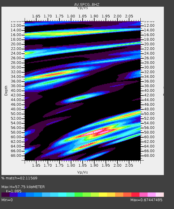
| Estimated Moho Depth: |
57.75 km |
| Estimated Crust Vp/Vs: |
1.89 |
| Assumed Crust Vp: |
6.566 km/s |
| Estimated Crust Vs: |
3.465 km/s |
| Estimated Crust Poisson's Ratio: |
0.31 |
|
| Radial Match: |
82.11569 % |
| Radial Bump: |
400 |
| Transverse Match: |
82.953354 % |
| Transverse Bump: |
400 |
| SOD ConfigId: |
28764291 |
| Insert Time: |
2022-08-12 16:47:30.245 +0000 |
| GWidth: |
2.5 |
| Max Bumps: |
400 |
| Tol: |
0.001 |
|

Signal To Noise
| Channel | StoN | STA | LTA |
| AV:SPCG: :BHZ:20220729T16:46:03.859987Z | 5.4857078 | 1.4585066E-7 | 2.6587392E-8 |
| AV:SPCG: :BHN:20220729T16:46:03.859987Z | 1.7432852 | 6.789007E-8 | 3.8943757E-8 |
| AV:SPCG: :BHE:20220729T16:46:03.859987Z | 2.234589 | 5.942288E-8 | 2.6592307E-8 |
| Arrivals |
| Ps | 8.5 SECOND |
| PpPs | 24 SECOND |
| PsPs/PpSs | 32 SECOND |


