You are here: Home > Network List > GS - US Geological Survey Networks Stations List
> Station DEC13 Justin Breden Machine Shed, Decatur, IL, USA > Earthquake Result Viewer
DEC13 Justin Breden Machine Shed, Decatur, IL, USA - Earthquake Result Viewer
| Earthquake location: |
Andreanof Islands, Aleutian Is. |
| Earthquake latitude/longitude: |
51.5/-177.9 |
| Earthquake time(UTC): |
2018/08/23 (235) 03:35:15 GMT |
| Earthquake Depth: |
44 km |
| Earthquake Magnitude: |
6.0 Ml |
| Earthquake Catalog/Contributor: |
NEIC PDE/us |
|
| Network: |
GS US Geological Survey Networks |
| Station: |
DEC13 Justin Breden Machine Shed, Decatur, IL, USA |
| Lat/Lon: |
39.90 N/88.88 W |
| Elevation: |
224 m |
|
| Distance: |
59.5 deg |
| Az: |
63.182 deg |
| Baz: |
313.532 deg |
| Ray Param: |
0.062037922 |
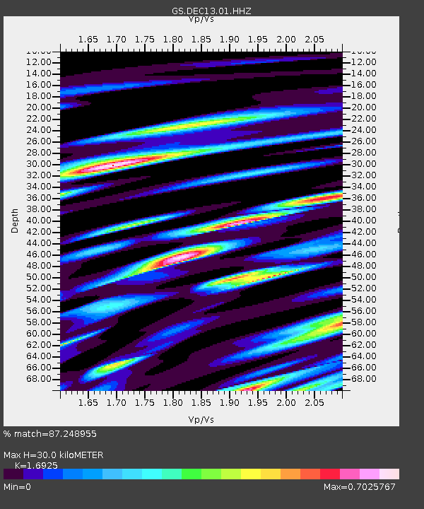
| Estimated Moho Depth: |
30.0 km |
| Estimated Crust Vp/Vs: |
1.69 |
| Assumed Crust Vp: |
6.444 km/s |
| Estimated Crust Vs: |
3.807 km/s |
| Estimated Crust Poisson's Ratio: |
0.23 |
|
| Radial Match: |
87.248955 % |
| Radial Bump: |
400 |
| Transverse Match: |
58.774727 % |
| Transverse Bump: |
400 |
| SOD ConfigId: |
2825771 |
| Insert Time: |
2018-09-06 03:49:35.314 +0000 |
| GWidth: |
2.5 |
| Max Bumps: |
400 |
| Tol: |
0.001 |
|

Signal To Noise
| Channel | StoN | STA | LTA |
| GS:DEC13:01:HHZ:20180823T03:44:44.08501Z | 12.10265 | 2.1012218E-6 | 1.7361668E-7 |
| GS:DEC13:01:HHN:20180823T03:44:44.08501Z | 2.6241145 | 8.483534E-7 | 3.2329132E-7 |
| GS:DEC13:01:HHE:20180823T03:44:44.08501Z | 2.997303 | 1.0250292E-6 | 3.4198382E-7 |
| Arrivals |
| Ps | 3.4 SECOND |
| PpPs | 12 SECOND |
| PsPs/PpSs | 15 SECOND |


