You are here: Home > Network List > CI - Caltech Regional Seismic Network Stations List
> Station SMM Simmler, CA, USA > Earthquake Result Viewer
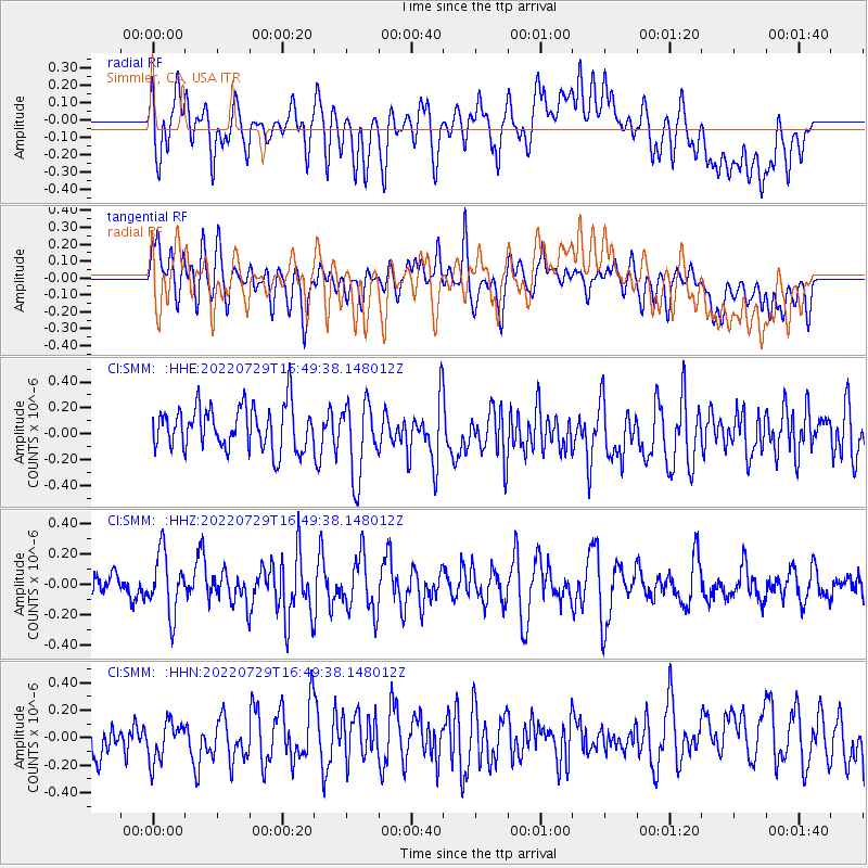
SMM Simmler, CA, USA - Earthquake Result Viewer
*The percent match for this event was below the threshold and hence no stack was calculated.
| Earthquake location: |
Kuril Islands |
| Earthquake latitude/longitude: |
44.1/149.2 |
| Earthquake time(UTC): |
2022/07/29 (210) 16:39:16 GMT |
| Earthquake Depth: |
10 km |
| Earthquake Magnitude: |
5.1 Mww |
| Earthquake Catalog/Contributor: |
NEIC PDE/us |
|
| Network: |
CI Caltech Regional Seismic Network |
| Station: |
SMM Simmler, CA, USA |
| Lat/Lon: |
35.31 N/120.00 W |
| Elevation: |
599 m |
|
| Distance: |
67.0 deg |
| Az: |
62.689 deg |
| Baz: |
308.539 deg |
| Ray Param: |
$rayparam |
*The percent match for this event was below the threshold and hence was not used in the summary stack. |
|
| Radial Match: |
54.343372 % |
| Radial Bump: |
400 |
| Transverse Match: |
51.434647 % |
| Transverse Bump: |
400 |
| SOD ConfigId: |
28764291 |
| Insert Time: |
2022-08-12 16:52:17.069 +0000 |
| GWidth: |
2.5 |
| Max Bumps: |
400 |
| Tol: |
0.001 |
|
Signal To Noise
| Channel | StoN | STA | LTA |
| CI:SMM: :HHZ:20220729T16:49:38.148012Z | 2.0278165 | 1.9958009E-7 | 9.842117E-8 |
| CI:SMM: :HHN:20220729T16:49:38.148012Z | 1.1526558 | 1.3975766E-7 | 1.2124838E-7 |
| CI:SMM: :HHE:20220729T16:49:38.148012Z | 1.7355834 | 2.8947238E-7 | 1.6678679E-7 |
| Arrivals |
| Ps | |
| PpPs | |
| PsPs/PpSs | |


