You are here: Home > Network List > GS - US Geological Survey Networks Stations List
> Station KAN13 Rinehart Farm > Earthquake Result Viewer
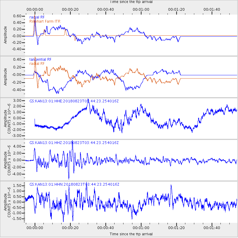
KAN13 Rinehart Farm - Earthquake Result Viewer
*The percent match for this event was below the threshold and hence no stack was calculated.
| Earthquake location: |
Andreanof Islands, Aleutian Is. |
| Earthquake latitude/longitude: |
51.5/-177.9 |
| Earthquake time(UTC): |
2018/08/23 (235) 03:35:15 GMT |
| Earthquake Depth: |
44 km |
| Earthquake Magnitude: |
6.0 Ml |
| Earthquake Catalog/Contributor: |
NEIC PDE/us |
|
| Network: |
GS US Geological Survey Networks |
| Station: |
KAN13 Rinehart Farm |
| Lat/Lon: |
37.01 N/97.48 W |
| Elevation: |
340 m |
|
| Distance: |
56.5 deg |
| Az: |
71.087 deg |
| Baz: |
312.389 deg |
| Ray Param: |
$rayparam |
*The percent match for this event was below the threshold and hence was not used in the summary stack. |
|
| Radial Match: |
34.294086 % |
| Radial Bump: |
400 |
| Transverse Match: |
21.992058 % |
| Transverse Bump: |
400 |
| SOD ConfigId: |
2825771 |
| Insert Time: |
2018-09-06 03:49:45.339 +0000 |
| GWidth: |
2.5 |
| Max Bumps: |
400 |
| Tol: |
0.001 |
|
Signal To Noise
| Channel | StoN | STA | LTA |
| GS:KAN13:01:HHZ:20180823T03:44:23.254016Z | 22.350752 | 1.4863621E-6 | 6.6501656E-8 |
| GS:KAN13:01:HHN:20180823T03:44:23.254016Z | 2.5084321 | 7.437828E-7 | 2.96513E-7 |
| GS:KAN13:01:HHE:20180823T03:44:23.254016Z | 3.969788 | 2.8849902E-6 | 7.267366E-7 |
| Arrivals |
| Ps | |
| PpPs | |
| PsPs/PpSs | |


