You are here: Home > Network List > CN - Canadian National Seismograph Network Stations List
> Station INK INUVIK, NT > Earthquake Result Viewer
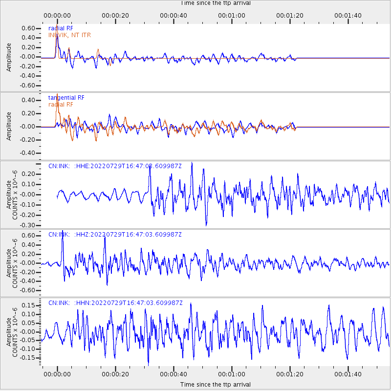
INK INUVIK, NT - Earthquake Result Viewer
*The percent match for this event was below the threshold and hence no stack was calculated.
| Earthquake location: |
Kuril Islands |
| Earthquake latitude/longitude: |
44.1/149.2 |
| Earthquake time(UTC): |
2022/07/29 (210) 16:39:16 GMT |
| Earthquake Depth: |
10 km |
| Earthquake Magnitude: |
5.1 Mww |
| Earthquake Catalog/Contributor: |
NEIC PDE/us |
|
| Network: |
CN Canadian National Seismograph Network |
| Station: |
INK INUVIK, NT |
| Lat/Lon: |
68.31 N/133.53 W |
| Elevation: |
44 m |
|
| Distance: |
45.3 deg |
| Az: |
30.671 deg |
| Baz: |
278.967 deg |
| Ray Param: |
$rayparam |
*The percent match for this event was below the threshold and hence was not used in the summary stack. |
|
| Radial Match: |
73.96429 % |
| Radial Bump: |
398 |
| Transverse Match: |
67.66859 % |
| Transverse Bump: |
400 |
| SOD ConfigId: |
28764291 |
| Insert Time: |
2022-08-12 16:53:49.644 +0000 |
| GWidth: |
2.5 |
| Max Bumps: |
400 |
| Tol: |
0.001 |
|
Signal To Noise
| Channel | StoN | STA | LTA |
| CN:INK: :HHZ:20220729T16:47:03.609987Z | 5.4774437 | 2.2486468E-7 | 4.105285E-8 |
| CN:INK: :HHN:20220729T16:47:03.609987Z | 1.2503785 | 3.9946983E-8 | 3.1947913E-8 |
| CN:INK: :HHE:20220729T16:47:03.609987Z | 3.393385 | 1.0710863E-7 | 3.156395E-8 |
| Arrivals |
| Ps | |
| PpPs | |
| PsPs/PpSs | |


