You are here: Home > Network List > TM - Thai Seismic Monitoring Network Stations List
> Station PANO PANO staion > Earthquake Result Viewer
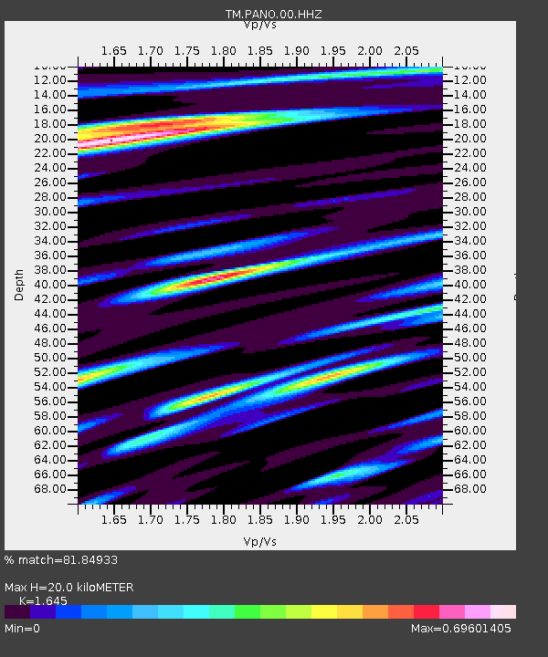
PANO PANO staion - Earthquake Result Viewer
| Earthquake location: |
Kuril Islands |
| Earthquake latitude/longitude: |
44.1/149.2 |
| Earthquake time(UTC): |
2022/07/29 (210) 16:39:16 GMT |
| Earthquake Depth: |
10 km |
| Earthquake Magnitude: |
5.1 Mww |
| Earthquake Catalog/Contributor: |
NEIC PDE/us |
|
| Network: |
TM Thai Seismic Monitoring Network |
| Station: |
PANO PANO staion |
| Lat/Lon: |
17.15 N/104.61 E |
| Elevation: |
136 m |
|
| Distance: |
46.1 deg |
| Az: |
248.705 deg |
| Baz: |
44.554 deg |
| Ray Param: |
0.07088122 |
| Estimated Moho Depth: |
20.0 km |
| Estimated Crust Vp/Vs: |
1.64 |
| Assumed Crust Vp: |
6.498 km/s |
| Estimated Crust Vs: |
3.95 km/s |
| Estimated Crust Poisson's Ratio: |
0.21 |
|
| Radial Match: |
81.84933 % |
| Radial Bump: |
400 |
| Transverse Match: |
77.948204 % |
| Transverse Bump: |
400 |
| SOD ConfigId: |
28764291 |
| Insert Time: |
2022-08-12 17:10:05.217 +0000 |
| GWidth: |
2.5 |
| Max Bumps: |
400 |
| Tol: |
0.001 |
|

Signal To Noise
| Channel | StoN | STA | LTA |
| TM:PANO:00:HHZ:20220729T16:47:09.709993Z | 6.827299 | 5.7548363E-8 | 8.429155E-9 |
| TM:PANO:00:HHN:20220729T16:47:09.709993Z | 2.0082366 | 2.1655866E-8 | 1.0783523E-8 |
| TM:PANO:00:HHE:20220729T16:47:09.709993Z | 1.143672 | 1.6537395E-8 | 1.4459911E-8 |
| Arrivals |
| Ps | 2.1 SECOND |
| PpPs | 7.6 SECOND |
| PsPs/PpSs | 9.7 SECOND |


