You are here: Home > Network List > AE - Arizona Broadband Seismic Network Stations List
> Station W18A Petrified Forest, AZ, USA > Earthquake Result Viewer
W18A Petrified Forest, AZ, USA - Earthquake Result Viewer
| Earthquake location: |
Off East Coast Of Kamchatka |
| Earthquake latitude/longitude: |
51.2/161.0 |
| Earthquake time(UTC): |
2022/07/29 (210) 23:05:43 GMT |
| Earthquake Depth: |
7.0 km |
| Earthquake Magnitude: |
5.6 Mww |
| Earthquake Catalog/Contributor: |
NEIC PDE/us |
|
| Network: |
AE Arizona Broadband Seismic Network |
| Station: |
W18A Petrified Forest, AZ, USA |
| Lat/Lon: |
35.12 N/109.74 W |
| Elevation: |
1750 m |
|
| Distance: |
63.2 deg |
| Az: |
66.722 deg |
| Baz: |
315.157 deg |
| Ray Param: |
0.05976024 |
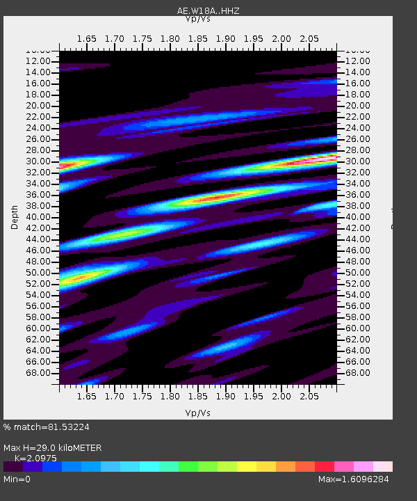
| Estimated Moho Depth: |
29.0 km |
| Estimated Crust Vp/Vs: |
2.10 |
| Assumed Crust Vp: |
6.496 km/s |
| Estimated Crust Vs: |
3.097 km/s |
| Estimated Crust Poisson's Ratio: |
0.35 |
|
| Radial Match: |
81.53224 % |
| Radial Bump: |
400 |
| Transverse Match: |
47.1147 % |
| Transverse Bump: |
400 |
| SOD ConfigId: |
28764291 |
| Insert Time: |
2022-08-12 23:08:15.675 +0000 |
| GWidth: |
2.5 |
| Max Bumps: |
400 |
| Tol: |
0.001 |
|

Signal To Noise
| Channel | StoN | STA | LTA |
| AE:W18A: :HHZ:20220729T23:15:40.61001Z | 10.425876 | 6.922554E-7 | 6.639782E-8 |
| AE:W18A: :HHN:20220729T23:15:40.61001Z | 3.6664708 | 2.1178997E-7 | 5.7763984E-8 |
| AE:W18A: :HHE:20220729T23:15:40.61001Z | 7.560966 | 3.6423612E-7 | 4.8173224E-8 |
| Arrivals |
| Ps | 5.1 SECOND |
| PpPs | 13 SECOND |
| PsPs/PpSs | 18 SECOND |


