You are here: Home > Network List > AK - Alaska Regional Network Stations List
> Station PS12 TAPS Pump Station 12, AK, USA > Earthquake Result Viewer
PS12 TAPS Pump Station 12, AK, USA - Earthquake Result Viewer
| Earthquake location: |
Off East Coast Of Kamchatka |
| Earthquake latitude/longitude: |
51.2/161.0 |
| Earthquake time(UTC): |
2022/07/29 (210) 23:05:43 GMT |
| Earthquake Depth: |
7.0 km |
| Earthquake Magnitude: |
5.6 Mww |
| Earthquake Catalog/Contributor: |
NEIC PDE/us |
|
| Network: |
AK Alaska Regional Network |
| Station: |
PS12 TAPS Pump Station 12, AK, USA |
| Lat/Lon: |
61.47 N/145.15 W |
| Elevation: |
563 m |
|
| Distance: |
30.7 deg |
| Az: |
49.415 deg |
| Baz: |
275.364 deg |
| Ray Param: |
0.07934104 |
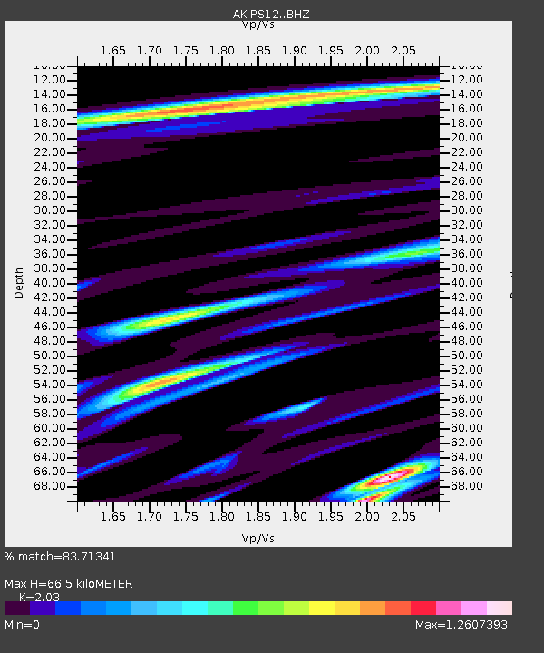
| Estimated Moho Depth: |
66.5 km |
| Estimated Crust Vp/Vs: |
2.03 |
| Assumed Crust Vp: |
6.566 km/s |
| Estimated Crust Vs: |
3.235 km/s |
| Estimated Crust Poisson's Ratio: |
0.34 |
|
| Radial Match: |
83.71341 % |
| Radial Bump: |
400 |
| Transverse Match: |
73.75844 % |
| Transverse Bump: |
400 |
| SOD ConfigId: |
28764291 |
| Insert Time: |
2022-08-12 23:09:46.978 +0000 |
| GWidth: |
2.5 |
| Max Bumps: |
400 |
| Tol: |
0.001 |
|

Signal To Noise
| Channel | StoN | STA | LTA |
| AK:PS12: :BHZ:20220729T23:11:27.968012Z | 13.362869 | 9.2823893E-7 | 6.946404E-8 |
| AK:PS12: :BHN:20220729T23:11:27.968012Z | 3.5884955 | 5.397999E-7 | 1.5042514E-7 |
| AK:PS12: :BHE:20220729T23:11:27.968012Z | 7.348513 | 6.693619E-7 | 9.108807E-8 |
| Arrivals |
| Ps | 11 SECOND |
| PpPs | 29 SECOND |
| PsPs/PpSs | 40 SECOND |


