You are here: Home > Network List > YW07 - Flexarray Along Cascadia Experiment for Segmentation Stations List
> Station FACU Phoenix, OR, USA > Earthquake Result Viewer
FACU Phoenix, OR, USA - Earthquake Result Viewer
| Earthquake location: |
Near S. Coast Of Honshu, Japan |
| Earthquake latitude/longitude: |
33.2/137.9 |
| Earthquake time(UTC): |
2009/08/09 (221) 10:55:55 GMT |
| Earthquake Depth: |
297 km |
| Earthquake Magnitude: |
6.5 MB, 7.1 MW, 7.1 MW |
| Earthquake Catalog/Contributor: |
WHDF/NEIC |
|
| Network: |
YW Flexarray Along Cascadia Experiment for Segmentation |
| Station: |
FACU Phoenix, OR, USA |
| Lat/Lon: |
42.26 N/122.83 W |
| Elevation: |
56 m |
|
| Distance: |
74.6 deg |
| Az: |
49.458 deg |
| Baz: |
300.844 deg |
| Ray Param: |
0.05136873 |
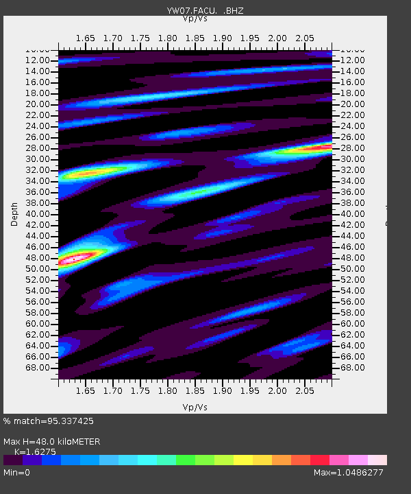
| Estimated Moho Depth: |
48.0 km |
| Estimated Crust Vp/Vs: |
1.63 |
| Assumed Crust Vp: |
6.522 km/s |
| Estimated Crust Vs: |
4.007 km/s |
| Estimated Crust Poisson's Ratio: |
0.20 |
|
| Radial Match: |
95.337425 % |
| Radial Bump: |
400 |
| Transverse Match: |
86.24104 % |
| Transverse Bump: |
400 |
| SOD ConfigId: |
2622 |
| Insert Time: |
2010-03-09 23:09:29.456 +0000 |
| GWidth: |
2.5 |
| Max Bumps: |
400 |
| Tol: |
0.001 |
|

Signal To Noise
| Channel | StoN | STA | LTA |
| YW:FACU: :BHZ:20090809T11:06:31.640029Z | 110.308044 | 1.1323198E-5 | 1.026507E-7 |
| YW:FACU: :BHN:20090809T11:06:31.640029Z | 63.821823 | 3.7120963E-6 | 5.816343E-8 |
| YW:FACU: :BHE:20090809T11:06:31.640029Z | 37.814312 | 3.5008534E-6 | 9.258011E-8 |
| Arrivals |
| Ps | 4.8 SECOND |
| PpPs | 19 SECOND |
| PsPs/PpSs | 23 SECOND |


