You are here: Home > Network List > YW07 - Flexarray Along Cascadia Experiment for Segmentation Stations List
> Station FACU Phoenix, OR, USA > Earthquake Result Viewer
FACU Phoenix, OR, USA - Earthquake Result Viewer
| Earthquake location: |
Samoa Islands Region |
| Earthquake latitude/longitude: |
-15.4/-172.3 |
| Earthquake time(UTC): |
2009/10/19 (292) 22:49:38 GMT |
| Earthquake Depth: |
18 km |
| Earthquake Magnitude: |
6.2 MB, 5.7 MS, 6.0 MW, 5.9 MW |
| Earthquake Catalog/Contributor: |
WHDF/NEIC |
|
| Network: |
YW Flexarray Along Cascadia Experiment for Segmentation |
| Station: |
FACU Phoenix, OR, USA |
| Lat/Lon: |
42.26 N/122.83 W |
| Elevation: |
56 m |
|
| Distance: |
73.2 deg |
| Az: |
36.1 deg |
| Baz: |
229.966 deg |
| Ray Param: |
0.053159256 |
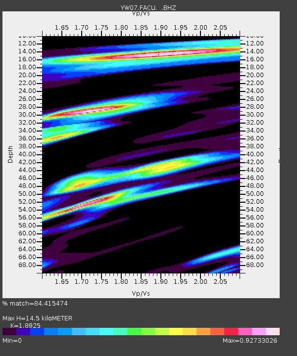
| Estimated Moho Depth: |
14.5 km |
| Estimated Crust Vp/Vs: |
1.89 |
| Assumed Crust Vp: |
6.522 km/s |
| Estimated Crust Vs: |
3.446 km/s |
| Estimated Crust Poisson's Ratio: |
0.31 |
|
| Radial Match: |
84.415474 % |
| Radial Bump: |
400 |
| Transverse Match: |
73.10773 % |
| Transverse Bump: |
400 |
| SOD ConfigId: |
2622 |
| Insert Time: |
2010-03-09 23:09:52.715 +0000 |
| GWidth: |
2.5 |
| Max Bumps: |
400 |
| Tol: |
0.001 |
|

Signal To Noise
| Channel | StoN | STA | LTA |
| YW:FACU: :BHZ:20091019T23:00:36.714016Z | 10.744479 | 1.5852804E-6 | 1.4754372E-7 |
| YW:FACU: :BHN:20091019T23:00:36.714016Z | 2.8620274 | 2.3921592E-7 | 8.358268E-8 |
| YW:FACU: :BHE:20091019T23:00:36.714016Z | 4.8265595 | 5.5950665E-7 | 1.15922454E-7 |
| Arrivals |
| Ps | 2.1 SECOND |
| PpPs | 6.2 SECOND |
| PsPs/PpSs | 8.3 SECOND |


