You are here: Home > Network List > YW07 - Flexarray Along Cascadia Experiment for Segmentation Stations List
> Station FACU Phoenix, OR, USA > Earthquake Result Viewer
FACU Phoenix, OR, USA - Earthquake Result Viewer
| Earthquake location: |
North Of Honduras |
| Earthquake latitude/longitude: |
16.7/-86.2 |
| Earthquake time(UTC): |
2009/05/28 (148) 08:24:45 GMT |
| Earthquake Depth: |
10 km |
| Earthquake Magnitude: |
6.7 MB, 7.2 MS, 7.3 MW, 7.3 MW |
| Earthquake Catalog/Contributor: |
WHDF/NEIC |
|
| Network: |
YW Flexarray Along Cascadia Experiment for Segmentation |
| Station: |
FACU Phoenix, OR, USA |
| Lat/Lon: |
42.26 N/122.83 W |
| Elevation: |
56 m |
|
| Distance: |
40.3 deg |
| Az: |
316.816 deg |
| Baz: |
117.955 deg |
| Ray Param: |
0.074479505 |
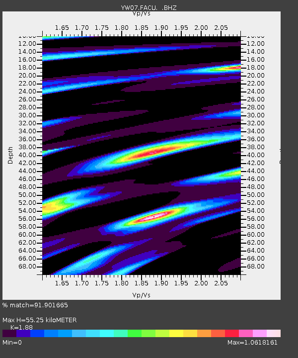
| Estimated Moho Depth: |
55.25 km |
| Estimated Crust Vp/Vs: |
1.88 |
| Assumed Crust Vp: |
6.522 km/s |
| Estimated Crust Vs: |
3.469 km/s |
| Estimated Crust Poisson's Ratio: |
0.30 |
|
| Radial Match: |
91.901665 % |
| Radial Bump: |
400 |
| Transverse Match: |
89.47531 % |
| Transverse Bump: |
400 |
| SOD ConfigId: |
2648 |
| Insert Time: |
2010-03-09 23:09:58.434 +0000 |
| GWidth: |
2.5 |
| Max Bumps: |
400 |
| Tol: |
0.001 |
|

Signal To Noise
| Channel | StoN | STA | LTA |
| YW:FACU: :BHZ:20090528T08:31:51.490004Z | 18.867016 | 2.468493E-6 | 1.3083643E-7 |
| YW:FACU: :BHN:20090528T08:31:51.490004Z | 7.947553 | 5.724067E-7 | 7.2023006E-8 |
| YW:FACU: :BHE:20090528T08:31:51.490004Z | 14.908138 | 1.5893518E-6 | 1.0660968E-7 |
| Arrivals |
| Ps | 8.0 SECOND |
| PpPs | 23 SECOND |
| PsPs/PpSs | 31 SECOND |


