You are here: Home > Network List > YW07 - Flexarray Along Cascadia Experiment for Segmentation Stations List
> Station FACU Phoenix, OR, USA > Earthquake Result Viewer
FACU Phoenix, OR, USA - Earthquake Result Viewer
| Earthquake location: |
Kuril Islands |
| Earthquake latitude/longitude: |
46.0/151.5 |
| Earthquake time(UTC): |
2009/04/07 (097) 04:23:33 GMT |
| Earthquake Depth: |
31 km |
| Earthquake Magnitude: |
6.5 MB, 6.8 MS, 6.9 MW, 6.9 MW |
| Earthquake Catalog/Contributor: |
WHDF/NEIC |
|
| Network: |
YW Flexarray Along Cascadia Experiment for Segmentation |
| Station: |
FACU Phoenix, OR, USA |
| Lat/Lon: |
42.26 N/122.83 W |
| Elevation: |
56 m |
|
| Distance: |
58.7 deg |
| Az: |
60.082 deg |
| Baz: |
305.599 deg |
| Ray Param: |
0.062651806 |
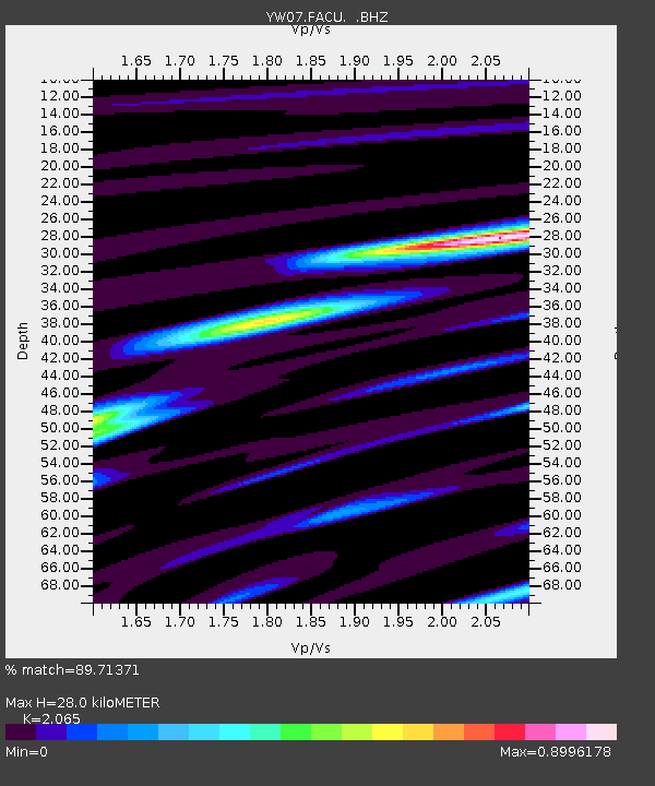
| Estimated Moho Depth: |
28.0 km |
| Estimated Crust Vp/Vs: |
2.07 |
| Assumed Crust Vp: |
6.522 km/s |
| Estimated Crust Vs: |
3.158 km/s |
| Estimated Crust Poisson's Ratio: |
0.35 |
|
| Radial Match: |
89.71371 % |
| Radial Bump: |
392 |
| Transverse Match: |
74.216675 % |
| Transverse Bump: |
400 |
| SOD ConfigId: |
2658 |
| Insert Time: |
2010-03-09 23:10:28.800 +0000 |
| GWidth: |
2.5 |
| Max Bumps: |
400 |
| Tol: |
0.001 |
|

Signal To Noise
| Channel | StoN | STA | LTA |
| YW:FACU: :BHZ:20090407T04:32:56.665015Z | 6.8796244 | 3.4715729E-6 | 5.0461665E-7 |
| YW:FACU: :BHN:20090407T04:32:56.665015Z | 3.1887271 | 1.2498764E-6 | 3.9196718E-7 |
| YW:FACU: :BHE:20090407T04:32:56.665015Z | 2.4546857 | 1.166795E-6 | 4.7533376E-7 |
| Arrivals |
| Ps | 4.8 SECOND |
| PpPs | 13 SECOND |
| PsPs/PpSs | 17 SECOND |


