You are here: Home > Network List > NM - Cooperative New Madrid Seismic Network Stations List
> Station FFIL Fairfield, IL > Earthquake Result Viewer
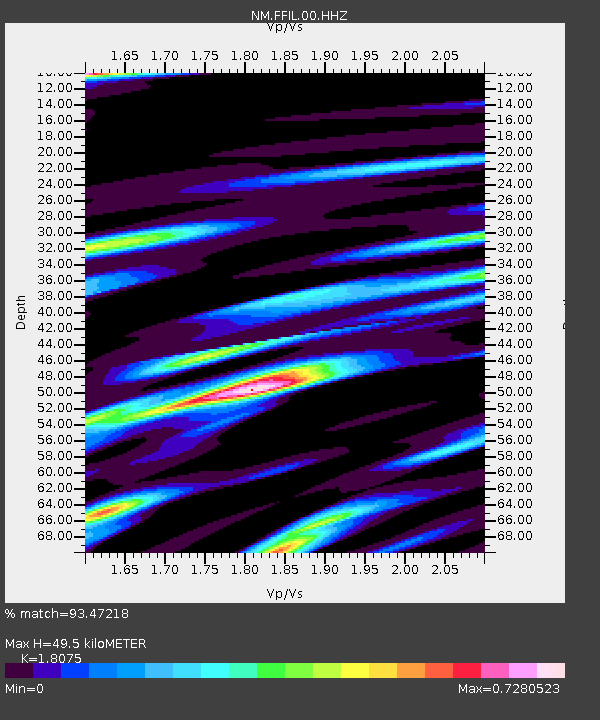
FFIL Fairfield, IL - Earthquake Result Viewer
| Earthquake location: |
Andreanof Islands, Aleutian Is. |
| Earthquake latitude/longitude: |
51.5/-177.9 |
| Earthquake time(UTC): |
2018/08/23 (235) 03:35:15 GMT |
| Earthquake Depth: |
44 km |
| Earthquake Magnitude: |
6.0 Ml |
| Earthquake Catalog/Contributor: |
NEIC PDE/us |
|
| Network: |
NM Cooperative New Madrid Seismic Network |
| Station: |
FFIL Fairfield, IL |
| Lat/Lon: |
38.38 N/88.39 W |
| Elevation: |
446 m |
|
| Distance: |
60.9 deg |
| Az: |
64.138 deg |
| Baz: |
314.314 deg |
| Ray Param: |
0.0611671 |
| Estimated Moho Depth: |
49.5 km |
| Estimated Crust Vp/Vs: |
1.81 |
| Assumed Crust Vp: |
6.444 km/s |
| Estimated Crust Vs: |
3.565 km/s |
| Estimated Crust Poisson's Ratio: |
0.28 |
|
| Radial Match: |
93.47218 % |
| Radial Bump: |
371 |
| Transverse Match: |
72.84464 % |
| Transverse Bump: |
400 |
| SOD ConfigId: |
2825771 |
| Insert Time: |
2018-09-06 03:53:07.917 +0000 |
| GWidth: |
2.5 |
| Max Bumps: |
400 |
| Tol: |
0.001 |
|

Signal To Noise
| Channel | StoN | STA | LTA |
| NM:FFIL:00:HHZ:20180823T03:44:53.148975Z | 20.689243 | 2.1484232E-6 | 1.0384251E-7 |
| NM:FFIL:00:HHN:20180823T03:44:53.148975Z | 5.3415327 | 9.4595407E-7 | 1.7709414E-7 |
| NM:FFIL:00:HHE:20180823T03:44:53.148975Z | 10.918095 | 8.003713E-7 | 7.330687E-8 |
| Arrivals |
| Ps | 6.5 SECOND |
| PpPs | 21 SECOND |
| PsPs/PpSs | 27 SECOND |


