You are here: Home > Network List > YW07 - Flexarray Along Cascadia Experiment for Segmentation Stations List
> Station FACU Phoenix, OR, USA > Earthquake Result Viewer
FACU Phoenix, OR, USA - Earthquake Result Viewer
| Earthquake location: |
Peru-Brazil Border Region |
| Earthquake latitude/longitude: |
-7.6/-74.4 |
| Earthquake time(UTC): |
2008/08/26 (239) 21:00:36 GMT |
| Earthquake Depth: |
154 km |
| Earthquake Magnitude: |
6.0 MB, 6.4 MW, 6.4 MW |
| Earthquake Catalog/Contributor: |
WHDF/NEIC |
|
| Network: |
YW Flexarray Along Cascadia Experiment for Segmentation |
| Station: |
FACU Phoenix, OR, USA |
| Lat/Lon: |
42.26 N/122.83 W |
| Elevation: |
56 m |
|
| Distance: |
66.4 deg |
| Az: |
322.693 deg |
| Baz: |
125.978 deg |
| Ray Param: |
0.057171427 |
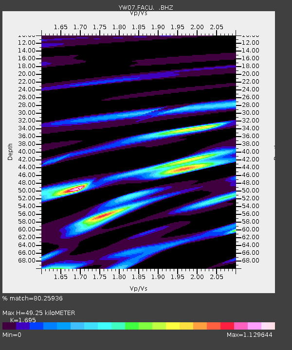
| Estimated Moho Depth: |
49.25 km |
| Estimated Crust Vp/Vs: |
1.70 |
| Assumed Crust Vp: |
6.522 km/s |
| Estimated Crust Vs: |
3.848 km/s |
| Estimated Crust Poisson's Ratio: |
0.23 |
|
| Radial Match: |
80.25936 % |
| Radial Bump: |
400 |
| Transverse Match: |
77.88455 % |
| Transverse Bump: |
400 |
| SOD ConfigId: |
2504 |
| Insert Time: |
2010-03-09 23:11:01.241 +0000 |
| GWidth: |
2.5 |
| Max Bumps: |
400 |
| Tol: |
0.001 |
|

Signal To Noise
| Channel | StoN | STA | LTA |
| YW:FACU: :BHZ:20080826T21:10:38.539016Z | 8.790467 | 1.2552342E-6 | 1.4279495E-7 |
| YW:FACU: :BHN:20080826T21:10:38.539016Z | 3.4437468 | 2.7291617E-7 | 7.924977E-8 |
| YW:FACU: :BHE:20080826T21:10:38.539016Z | 7.954901 | 6.9364637E-7 | 8.7197364E-8 |
| Arrivals |
| Ps | 5.5 SECOND |
| PpPs | 19 SECOND |
| PsPs/PpSs | 25 SECOND |


