You are here: Home > Network List > GM - US Geological Survey Networks Stations List
> Station NMP02 New Mexico Permian - Site# 02 > Earthquake Result Viewer
NMP02 New Mexico Permian - Site# 02 - Earthquake Result Viewer
| Earthquake location: |
Off East Coast Of Kamchatka |
| Earthquake latitude/longitude: |
51.2/161.0 |
| Earthquake time(UTC): |
2022/07/29 (210) 23:05:43 GMT |
| Earthquake Depth: |
7.0 km |
| Earthquake Magnitude: |
5.6 Mww |
| Earthquake Catalog/Contributor: |
NEIC PDE/us |
|
| Network: |
GM US Geological Survey Networks |
| Station: |
NMP02 New Mexico Permian - Site# 02 |
| Lat/Lon: |
32.09 N/103.86 W |
| Elevation: |
996 m |
|
| Distance: |
68.7 deg |
| Az: |
65.108 deg |
| Baz: |
317.738 deg |
| Ray Param: |
0.05612109 |
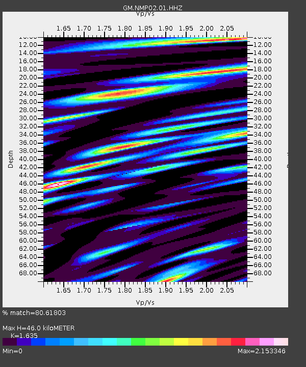
| Estimated Moho Depth: |
46.0 km |
| Estimated Crust Vp/Vs: |
1.63 |
| Assumed Crust Vp: |
6.129 km/s |
| Estimated Crust Vs: |
3.749 km/s |
| Estimated Crust Poisson's Ratio: |
0.20 |
|
| Radial Match: |
80.61803 % |
| Radial Bump: |
400 |
| Transverse Match: |
61.820877 % |
| Transverse Bump: |
400 |
| SOD ConfigId: |
28764291 |
| Insert Time: |
2022-08-12 23:27:32.558 +0000 |
| GWidth: |
2.5 |
| Max Bumps: |
400 |
| Tol: |
0.001 |
|

Signal To Noise
| Channel | StoN | STA | LTA |
| GM:NMP02:01:HHZ:20220729T23:16:16.339991Z | 6.658279 | 1.0211785E-6 | 1.5336973E-7 |
| GM:NMP02:01:HHN:20220729T23:16:16.339991Z | 4.165271 | 4.132599E-7 | 9.921561E-8 |
| GM:NMP02:01:HHE:20220729T23:16:16.339991Z | 3.6656497 | 3.5281795E-7 | 9.624977E-8 |
| Arrivals |
| Ps | 4.9 SECOND |
| PpPs | 19 SECOND |
| PsPs/PpSs | 24 SECOND |


