You are here: Home > Network List > IW - Intermountain West Stations List
> Station PLID Pearl Lake, Idaho, USA > Earthquake Result Viewer
PLID Pearl Lake, Idaho, USA - Earthquake Result Viewer
| Earthquake location: |
Off East Coast Of Kamchatka |
| Earthquake latitude/longitude: |
51.2/161.0 |
| Earthquake time(UTC): |
2022/07/29 (210) 23:05:43 GMT |
| Earthquake Depth: |
7.0 km |
| Earthquake Magnitude: |
5.6 Mww |
| Earthquake Catalog/Contributor: |
NEIC PDE/us |
|
| Network: |
IW Intermountain West |
| Station: |
PLID Pearl Lake, Idaho, USA |
| Lat/Lon: |
45.09 N/116.00 W |
| Elevation: |
2164 m |
|
| Distance: |
52.9 deg |
| Az: |
61.773 deg |
| Baz: |
308.491 deg |
| Ray Param: |
0.066445075 |
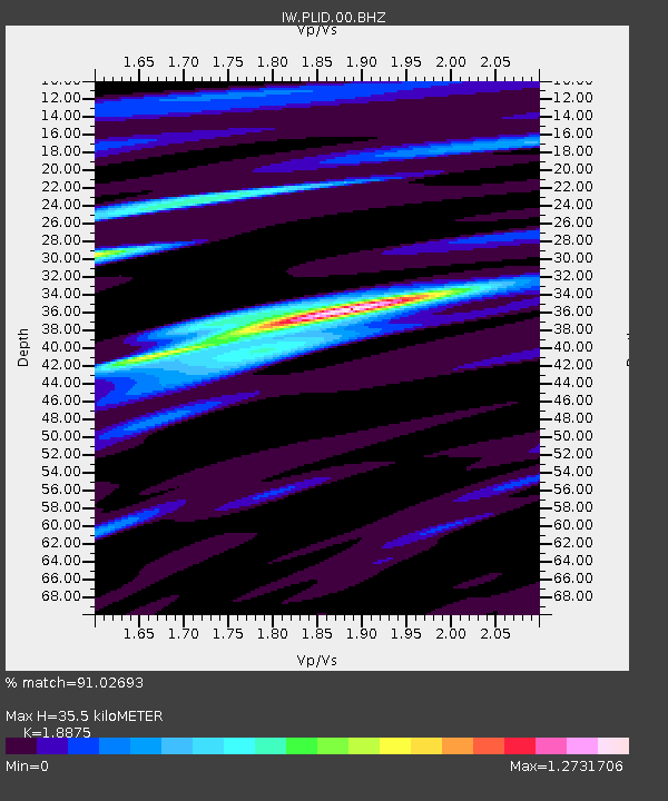
| Estimated Moho Depth: |
35.5 km |
| Estimated Crust Vp/Vs: |
1.89 |
| Assumed Crust Vp: |
6.571 km/s |
| Estimated Crust Vs: |
3.481 km/s |
| Estimated Crust Poisson's Ratio: |
0.30 |
|
| Radial Match: |
91.02693 % |
| Radial Bump: |
400 |
| Transverse Match: |
73.834435 % |
| Transverse Bump: |
400 |
| SOD ConfigId: |
28764291 |
| Insert Time: |
2022-08-12 23:32:52.329 +0000 |
| GWidth: |
2.5 |
| Max Bumps: |
400 |
| Tol: |
0.001 |
|

Signal To Noise
| Channel | StoN | STA | LTA |
| IW:PLID:00:BHZ:20220729T23:14:29.100Z | 13.702178 | 7.540899E-7 | 5.5034313E-8 |
| IW:PLID:00:BH1:20220729T23:14:29.100Z | 7.0972095 | 2.359993E-7 | 3.3252405E-8 |
| IW:PLID:00:BH2:20220729T23:14:29.100Z | 9.943404 | 2.6621504E-7 | 2.6773028E-8 |
| Arrivals |
| Ps | 5.1 SECOND |
| PpPs | 15 SECOND |
| PsPs/PpSs | 20 SECOND |


