You are here: Home > Network List > CT - California Transect Network Stations List
> Station FERN Fern Peak, California > Earthquake Result Viewer
FERN Fern Peak, California - Earthquake Result Viewer
| Earthquake location: |
Tonga Islands |
| Earthquake latitude/longitude: |
-15.2/-173.6 |
| Earthquake time(UTC): |
1995/04/07 (097) 22:06:58 GMT |
| Earthquake Depth: |
31 km |
| Earthquake Magnitude: |
6.7 MB, 8.0 MS, 7.5 UNKNOWN, 7.1 MD |
| Earthquake Catalog/Contributor: |
WHDF/NEIC |
|
| Network: |
CT California Transect Network |
| Station: |
FERN Fern Peak, California |
| Lat/Lon: |
37.15 N/121.81 W |
| Elevation: |
518 m |
|
| Distance: |
71.3 deg |
| Az: |
41.508 deg |
| Baz: |
233.213 deg |
| Ray Param: |
0.054378547 |
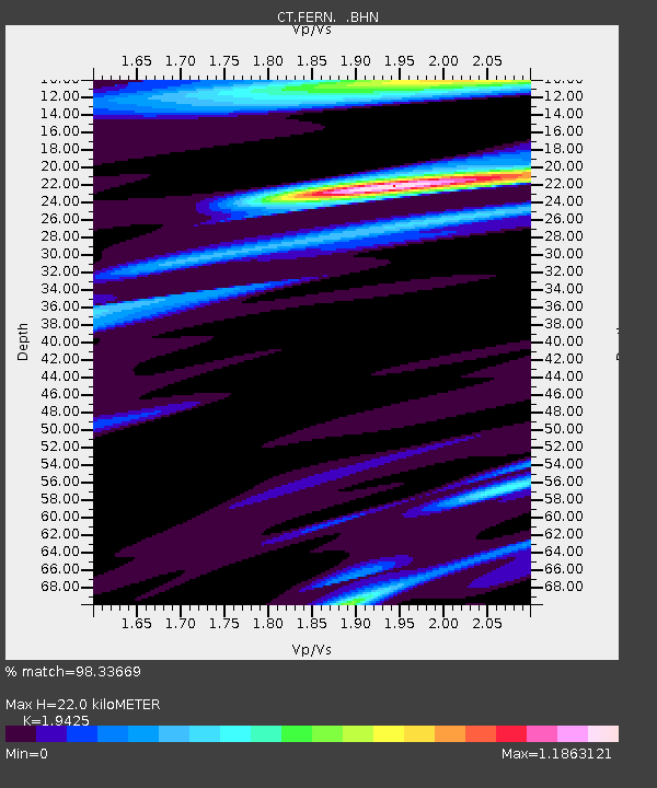
| Estimated Moho Depth: |
22.0 km |
| Estimated Crust Vp/Vs: |
1.94 |
| Assumed Crust Vp: |
6.391 km/s |
| Estimated Crust Vs: |
3.29 km/s |
| Estimated Crust Poisson's Ratio: |
0.32 |
|
| Radial Match: |
98.33669 % |
| Radial Bump: |
296 |
| Transverse Match: |
90.50732 % |
| Transverse Bump: |
400 |
| SOD ConfigId: |
6273 |
| Insert Time: |
2010-03-09 23:15:51.675 +0000 |
| GWidth: |
2.5 |
| Max Bumps: |
400 |
| Tol: |
0.001 |
|

Signal To Noise
| Channel | StoN | STA | LTA |
| CT:FERN: :BHN:19950407T22:17:43.497009Z | 1.7907807 | 9.554403E-7 | 5.335329E-7 |
| CT:FERN: :BHE:19950407T22:17:43.497009Z | 1.9310857 | 1.9134543E-6 | 9.908696E-7 |
| CT:FERN: :BHZ:19950407T22:17:43.497009Z | 9.036879 | 5.262044E-6 | 5.8228557E-7 |
| Arrivals |
| Ps | 3.4 SECOND |
| PpPs | 9.8 SECOND |
| PsPs/PpSs | 13 SECOND |


