You are here: Home > Network List > US - United States National Seismic Network Stations List
> Station EGMT Eagleton, Montana, USA > Earthquake Result Viewer
EGMT Eagleton, Montana, USA - Earthquake Result Viewer
| Earthquake location: |
Andreanof Islands, Aleutian Is. |
| Earthquake latitude/longitude: |
51.5/-177.9 |
| Earthquake time(UTC): |
2018/08/23 (235) 03:35:15 GMT |
| Earthquake Depth: |
44 km |
| Earthquake Magnitude: |
6.0 Ml |
| Earthquake Catalog/Contributor: |
NEIC PDE/us |
|
| Network: |
US United States National Seismic Network |
| Station: |
EGMT Eagleton, Montana, USA |
| Lat/Lon: |
48.02 N/109.75 W |
| Elevation: |
1055 m |
|
| Distance: |
42.7 deg |
| Az: |
66.727 deg |
| Baz: |
301.22 deg |
| Ray Param: |
0.0729117 |
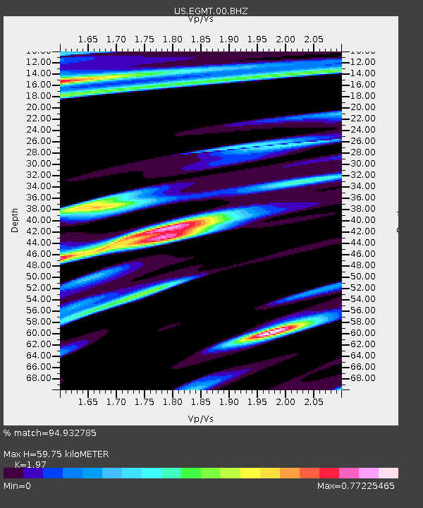
| Estimated Moho Depth: |
59.75 km |
| Estimated Crust Vp/Vs: |
1.97 |
| Assumed Crust Vp: |
6.438 km/s |
| Estimated Crust Vs: |
3.268 km/s |
| Estimated Crust Poisson's Ratio: |
0.33 |
|
| Radial Match: |
94.932785 % |
| Radial Bump: |
382 |
| Transverse Match: |
87.14787 % |
| Transverse Bump: |
400 |
| SOD ConfigId: |
2825771 |
| Insert Time: |
2018-09-06 03:56:17.708 +0000 |
| GWidth: |
2.5 |
| Max Bumps: |
400 |
| Tol: |
0.001 |
|
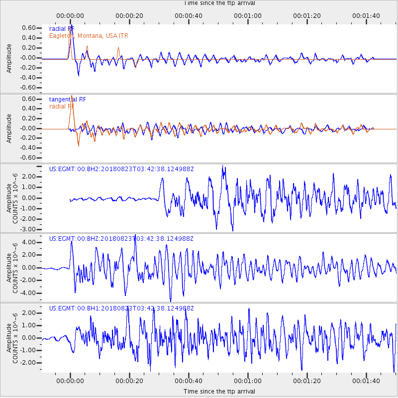
Signal To Noise
| Channel | StoN | STA | LTA |
| US:EGMT:00:BHZ:20180823T03:42:38.124988Z | 22.098917 | 1.8796535E-6 | 8.5056364E-8 |
| US:EGMT:00:BH1:20180823T03:42:38.124988Z | 5.0860357 | 6.3432196E-7 | 1.2471835E-7 |
| US:EGMT:00:BH2:20180823T03:42:38.124988Z | 11.119972 | 1.0669335E-6 | 9.594749E-8 |
| Arrivals |
| Ps | 9.6 SECOND |
| PpPs | 26 SECOND |
| PsPs/PpSs | 36 SECOND |


