You are here: Home > Network List > YX16 - Raton Basin UNM Broadband Network Stations List
> Station UNM5 Southernmost CO Station > Earthquake Result Viewer
UNM5 Southernmost CO Station - Earthquake Result Viewer
| Earthquake location: |
Off East Coast Of Kamchatka |
| Earthquake latitude/longitude: |
51.2/161.0 |
| Earthquake time(UTC): |
2022/07/29 (210) 23:05:43 GMT |
| Earthquake Depth: |
7.0 km |
| Earthquake Magnitude: |
5.6 Mww |
| Earthquake Catalog/Contributor: |
NEIC PDE/us |
|
| Network: |
YX Raton Basin UNM Broadband Network |
| Station: |
UNM5 Southernmost CO Station |
| Lat/Lon: |
37.12 N/104.78 W |
| Elevation: |
2035 m |
|
| Distance: |
64.6 deg |
| Az: |
61.974 deg |
| Baz: |
315.973 deg |
| Ray Param: |
0.058858685 |
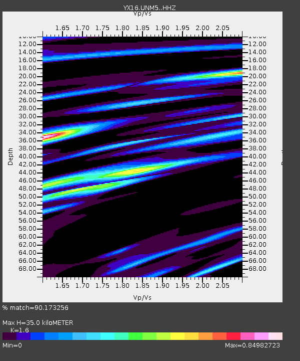
| Estimated Moho Depth: |
35.0 km |
| Estimated Crust Vp/Vs: |
1.60 |
| Assumed Crust Vp: |
6.316 km/s |
| Estimated Crust Vs: |
3.947 km/s |
| Estimated Crust Poisson's Ratio: |
0.18 |
|
| Radial Match: |
90.173256 % |
| Radial Bump: |
400 |
| Transverse Match: |
63.95743 % |
| Transverse Bump: |
400 |
| SOD ConfigId: |
28764291 |
| Insert Time: |
2022-08-13 00:09:11.554 +0000 |
| GWidth: |
2.5 |
| Max Bumps: |
400 |
| Tol: |
0.001 |
|

Signal To Noise
| Channel | StoN | STA | LTA |
| YX:UNM5: :HHZ:20220729T23:15:49.690027Z | 26.23293 | 1.2404978E-6 | 4.7287813E-8 |
| YX:UNM5: :HHN:20220729T23:15:49.690027Z | 5.130874 | 2.8635674E-7 | 5.5810517E-8 |
| YX:UNM5: :HHE:20220729T23:15:49.690027Z | 6.5200953 | 2.3256568E-7 | 3.5669064E-8 |
| Arrivals |
| Ps | 3.5 SECOND |
| PpPs | 14 SECOND |
| PsPs/PpSs | 17 SECOND |


