You are here: Home > Network List > CT - California Transect Network Stations List
> Station ICAN Ingram Canyon, California > Earthquake Result Viewer
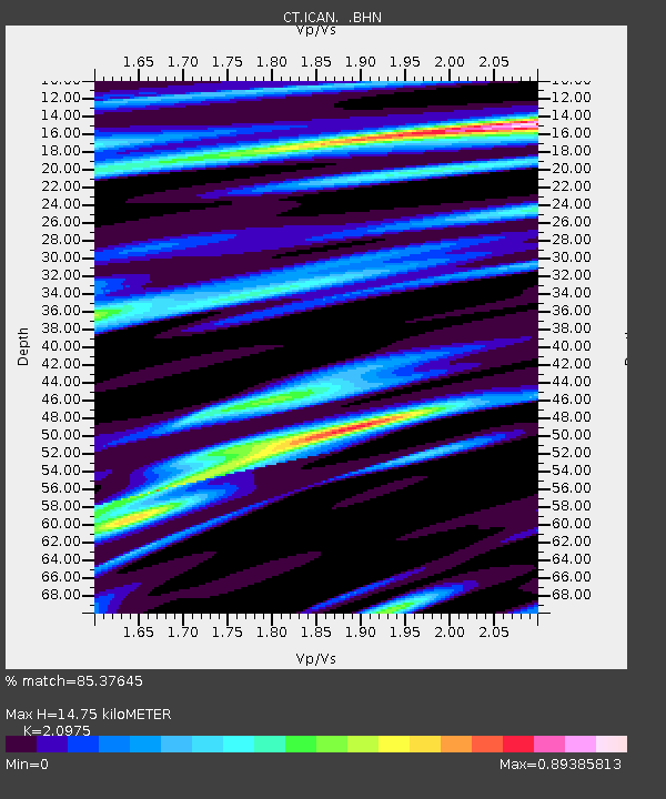
ICAN Ingram Canyon, California - Earthquake Result Viewer
| Earthquake location: |
Off Coast Of Chiapas, Mexico |
| Earthquake latitude/longitude: |
15.0/-94.3 |
| Earthquake time(UTC): |
1995/09/06 (249) 22:48:52 GMT |
| Earthquake Depth: |
33 km |
| Earthquake Magnitude: |
5.8 MB, 5.5 MS |
| Earthquake Catalog/Contributor: |
WHDF/NEIC |
|
| Network: |
CT California Transect Network |
| Station: |
ICAN Ingram Canyon, California |
| Lat/Lon: |
37.50 N/121.33 W |
| Elevation: |
312 m |
|
| Distance: |
32.9 deg |
| Az: |
318.138 deg |
| Baz: |
125.81 deg |
| Ray Param: |
0.07842506 |
| Estimated Moho Depth: |
14.75 km |
| Estimated Crust Vp/Vs: |
2.10 |
| Assumed Crust Vp: |
6.391 km/s |
| Estimated Crust Vs: |
3.047 km/s |
| Estimated Crust Poisson's Ratio: |
0.35 |
|
| Radial Match: |
85.37645 % |
| Radial Bump: |
400 |
| Transverse Match: |
73.52278 % |
| Transverse Bump: |
400 |
| SOD ConfigId: |
9875 |
| Insert Time: |
2010-03-09 23:17:15.892 +0000 |
| GWidth: |
2.5 |
| Max Bumps: |
400 |
| Tol: |
0.001 |
|

Signal To Noise
| Channel | StoN | STA | LTA |
| CT:ICAN: :BHN:19950906T22:54:52.937006Z | 1.5082029 | 1.9523004E-7 | 1.2944548E-7 |
| CT:ICAN: :BHE:19950906T22:54:52.937006Z | 1.4928596 | 2.385529E-7 | 1.5979595E-7 |
| CT:ICAN: :BHZ:19950906T22:54:52.937006Z | 4.9709153 | 5.432082E-7 | 1.0927731E-7 |
| Arrivals |
| Ps | 2.7 SECOND |
| PpPs | 6.7 SECOND |
| PsPs/PpSs | 9.4 SECOND |


