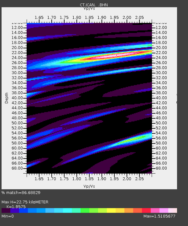
ICAN Ingram Canyon, California - Earthquake Result Viewer

Earthquake location: Unimak Island Region, Alaska
Earthquake latitude/longitude: 53.6/-163.5
Earthquake time(UTC): 1995/07/08 (189) 17:15:28 GMT
Earthquake Depth: 33 km
Earthquake Magnitude: 5.8 MB, 5.7 MS, 5.5 UNKNOWN, 6.0 MW
Earthquake Catalog/Contributor: WHDF/NEIC
Network: CT California Transect Network
Station: ICAN Ingram Canyon, California
Lat/Lon: 37.50 N/121.33 W
Elevation: 312 m
Distance: 33.1 deg
Az: 101.866 deg
Baz: 312.893 deg
Ray Param: 0.07831128
Estimated Moho Depth: 22.75 km
Estimated Crust Vp/Vs: 1.96
Assumed Crust Vp: 6.391 km/s
Estimated Crust Vs: 3.265 km/s
Estimated Crust Poisson's Ratio: 0.32
Radial Match: 86.68829 %
Radial Bump: 326
Transverse Match: 73.32199 %
Transverse Bump: 400
SOD ConfigId: 6273
Insert Time: 2010-03-09 23:17:29.434 +0000
GWidth: 2.5
Max Bumps: 400
Tol: 0.001

Signal To Noise

ChannelStoNSTALTA
CT:ICAN: :BHN:19950708T17:21:30.596002Z3.44986131.5377579E-74.4574485E-8
CT:ICAN: :BHE:19950708T17:21:30.596002Z1.41910291.0203791E-77.190311E-8
CT:ICAN: :BHZ:19950708T17:21:30.596002Z8.04381753.6532992E-74.5417483E-8
Arrivals
Ps3.7 SECOND
PpPs9.8 SECOND
PsPs/PpSs13 SECOND