You are here: Home > Network List > CT - California Transect Network Stations List
> Station ICAN Ingram Canyon, California > Earthquake Result Viewer
ICAN Ingram Canyon, California - Earthquake Result Viewer
| Earthquake location: |
Mariana Islands |
| Earthquake latitude/longitude: |
18.9/145.2 |
| Earthquake time(UTC): |
1995/08/23 (235) 07:06:02 GMT |
| Earthquake Depth: |
596 km |
| Earthquake Magnitude: |
6.3 MB, 6.3 UNKNOWN, 7.0 MW |
| Earthquake Catalog/Contributor: |
WHDF/NEIC |
|
| Network: |
CT California Transect Network |
| Station: |
ICAN Ingram Canyon, California |
| Lat/Lon: |
37.50 N/121.33 W |
| Elevation: |
312 m |
|
| Distance: |
81.4 deg |
| Az: |
53.394 deg |
| Baz: |
287.079 deg |
| Ray Param: |
0.04577294 |
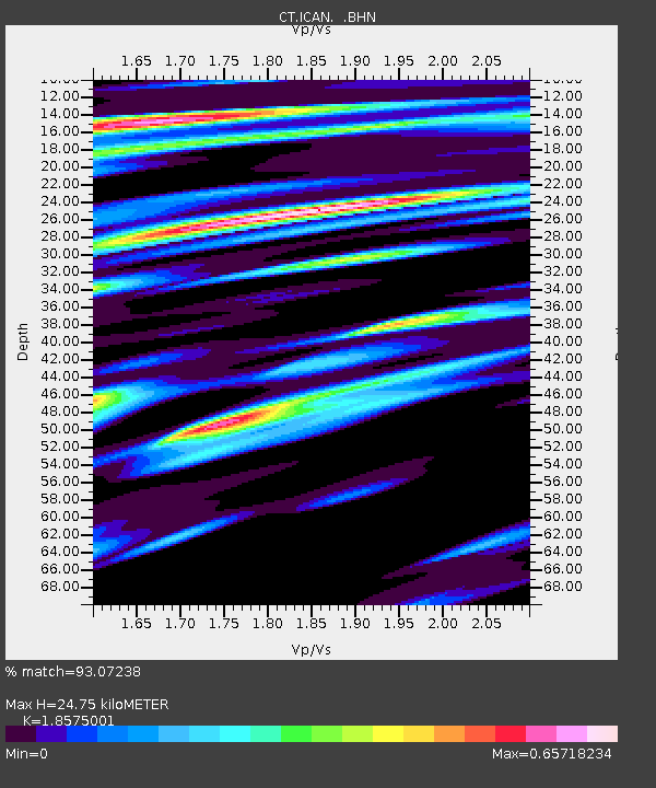
| Estimated Moho Depth: |
24.75 km |
| Estimated Crust Vp/Vs: |
1.86 |
| Assumed Crust Vp: |
6.391 km/s |
| Estimated Crust Vs: |
3.44 km/s |
| Estimated Crust Poisson's Ratio: |
0.30 |
|
| Radial Match: |
93.07238 % |
| Radial Bump: |
400 |
| Transverse Match: |
90.88792 % |
| Transverse Bump: |
400 |
| SOD ConfigId: |
6273 |
| Insert Time: |
2010-03-09 23:17:45.903 +0000 |
| GWidth: |
2.5 |
| Max Bumps: |
400 |
| Tol: |
0.001 |
|

Signal To Noise
| Channel | StoN | STA | LTA |
| CT:ICAN: :BHN:19950823T07:16:47.237024Z | 5.459698 | 5.525922E-7 | 1.0121296E-7 |
| CT:ICAN: :BHE:19950823T07:16:47.237024Z | 7.5172415 | 7.1671997E-7 | 9.534348E-8 |
| CT:ICAN: :BHZ:19950823T07:16:47.237024Z | 31.892813 | 3.5058122E-6 | 1.09924834E-7 |
| Arrivals |
| Ps | 3.4 SECOND |
| PpPs | 11 SECOND |
| PsPs/PpSs | 14 SECOND |


