You are here: Home > Network List > UU - University of Utah Regional Network Stations List
> Station HMU Henry Mountain, UT, USA > Earthquake Result Viewer
HMU Henry Mountain, UT, USA - Earthquake Result Viewer
| Earthquake location: |
Andreanof Islands, Aleutian Is. |
| Earthquake latitude/longitude: |
51.5/-177.9 |
| Earthquake time(UTC): |
2018/08/23 (235) 03:35:15 GMT |
| Earthquake Depth: |
44 km |
| Earthquake Magnitude: |
6.0 Ml |
| Earthquake Catalog/Contributor: |
NEIC PDE/us |
|
| Network: |
UU University of Utah Regional Network |
| Station: |
HMU Henry Mountain, UT, USA |
| Lat/Lon: |
37.94 N/110.74 W |
| Elevation: |
2430 m |
|
| Distance: |
47.9 deg |
| Az: |
78.91 deg |
| Baz: |
309.139 deg |
| Ray Param: |
0.069572255 |
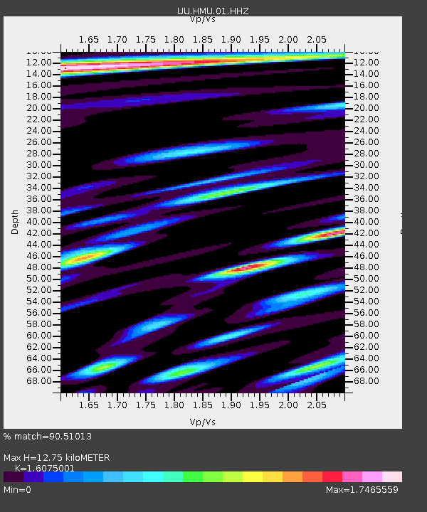
| Estimated Moho Depth: |
12.75 km |
| Estimated Crust Vp/Vs: |
1.61 |
| Assumed Crust Vp: |
6.247 km/s |
| Estimated Crust Vs: |
3.886 km/s |
| Estimated Crust Poisson's Ratio: |
0.18 |
|
| Radial Match: |
90.51013 % |
| Radial Bump: |
400 |
| Transverse Match: |
81.96744 % |
| Transverse Bump: |
400 |
| SOD ConfigId: |
2825771 |
| Insert Time: |
2018-09-06 03:57:56.147 +0000 |
| GWidth: |
2.5 |
| Max Bumps: |
400 |
| Tol: |
0.001 |
|

Signal To Noise
| Channel | StoN | STA | LTA |
| UU:HMU:01:HHZ:20180823T03:43:19.547992Z | 12.941963 | 4.3137824E-8 | 3.3331746E-9 |
| UU:HMU:01:HHN:20180823T03:43:19.547992Z | 10.666195 | 2.4932538E-8 | 2.3375288E-9 |
| UU:HMU:01:HHE:20180823T03:43:19.547992Z | 4.09713 | 1.7728064E-8 | 4.326947E-9 |
| Arrivals |
| Ps | 1.3 SECOND |
| PpPs | 5.0 SECOND |
| PsPs/PpSs | 6.3 SECOND |


