You are here: Home > Network List > CT - California Transect Network Stations List
> Station SAVY San Antonio Valley, California > Earthquake Result Viewer
SAVY San Antonio Valley, California - Earthquake Result Viewer
| Earthquake location: |
Solomon Islands |
| Earthquake latitude/longitude: |
-5.8/154.3 |
| Earthquake time(UTC): |
1995/08/16 (228) 23:10:28 GMT |
| Earthquake Depth: |
74 km |
| Earthquake Magnitude: |
6.1 MB, 7.2 MS, 7.2 UNKNOWN, 7.2 MW |
| Earthquake Catalog/Contributor: |
WHDF/NEIC |
|
| Network: |
CT California Transect Network |
| Station: |
SAVY San Antonio Valley, California |
| Lat/Lon: |
37.39 N/121.50 W |
| Elevation: |
600 m |
|
| Distance: |
88.9 deg |
| Az: |
52.432 deg |
| Baz: |
261.951 deg |
| Ray Param: |
0.042091817 |
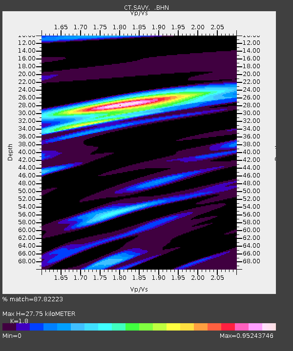
| Estimated Moho Depth: |
27.75 km |
| Estimated Crust Vp/Vs: |
1.80 |
| Assumed Crust Vp: |
6.391 km/s |
| Estimated Crust Vs: |
3.55 km/s |
| Estimated Crust Poisson's Ratio: |
0.28 |
|
| Radial Match: |
87.82223 % |
| Radial Bump: |
400 |
| Transverse Match: |
83.206604 % |
| Transverse Bump: |
400 |
| SOD ConfigId: |
6273 |
| Insert Time: |
2010-03-09 23:19:03.761 +0000 |
| GWidth: |
2.5 |
| Max Bumps: |
400 |
| Tol: |
0.001 |
|

Signal To Noise
| Channel | StoN | STA | LTA |
| CT:SAVY: :BHN:19950816T23:22:43.985022Z | 0.88699627 | 1.7490585E-7 | 1.9718895E-7 |
| CT:SAVY: :BHE:19950816T23:22:43.985022Z | 1.1690992 | 2.5105436E-7 | 2.147417E-7 |
| CT:SAVY: :BHZ:19950816T23:22:43.985022Z | 5.4862328 | 6.2198575E-7 | 1.1337211E-7 |
| Arrivals |
| Ps | 3.5 SECOND |
| PpPs | 12 SECOND |
| PsPs/PpSs | 15 SECOND |


