You are here: Home > Network List > GS - US Geological Survey Networks Stations List
> Station KAN16 SW of Harper, Kansas - Bergman residence > Earthquake Result Viewer
KAN16 SW of Harper, Kansas - Bergman residence - Earthquake Result Viewer
| Earthquake location: |
Fiji Islands Region |
| Earthquake latitude/longitude: |
-18.2/-178.2 |
| Earthquake time(UTC): |
2018/08/23 (235) 03:41:16 GMT |
| Earthquake Depth: |
544 km |
| Earthquake Magnitude: |
5.5 mb |
| Earthquake Catalog/Contributor: |
NEIC PDE/us |
|
| Network: |
GS US Geological Survey Networks |
| Station: |
KAN16 SW of Harper, Kansas - Bergman residence |
| Lat/Lon: |
37.23 N/98.06 W |
| Elevation: |
435 m |
|
| Distance: |
93.3 deg |
| Az: |
51.972 deg |
| Baz: |
249.765 deg |
| Ray Param: |
0.040830556 |
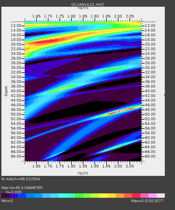
| Estimated Moho Depth: |
48.5 km |
| Estimated Crust Vp/Vs: |
2.01 |
| Assumed Crust Vp: |
6.426 km/s |
| Estimated Crust Vs: |
3.205 km/s |
| Estimated Crust Poisson's Ratio: |
0.33 |
|
| Radial Match: |
99.832504 % |
| Radial Bump: |
30 |
| Transverse Match: |
99.3203 % |
| Transverse Bump: |
93 |
| SOD ConfigId: |
2825771 |
| Insert Time: |
2018-09-06 04:02:05.130 +0000 |
| GWidth: |
2.5 |
| Max Bumps: |
400 |
| Tol: |
0.001 |
|

Signal To Noise
| Channel | StoN | STA | LTA |
| GS:KAN16:01:HHZ:20180823T03:53:01.593972Z | 2.0426903 | 4.937899E-8 | 2.417351E-8 |
| GS:KAN16:01:HHN:20180823T03:53:01.593972Z | 2.1572647 | 2.4032602E-8 | 1.1140312E-8 |
| GS:KAN16:01:HHE:20180823T03:53:01.593972Z | 2.1285312 | 3.5937983E-8 | 1.6883936E-8 |
| Arrivals |
| Ps | 7.7 SECOND |
| PpPs | 22 SECOND |
| PsPs/PpSs | 30 SECOND |


