You are here: Home > Network List > AV - Alaska Volcano Observatory Stations List
> Station TAPA Point Aries, Tanaga Volcano, Alaska > Earthquake Result Viewer
TAPA Point Aries, Tanaga Volcano, Alaska - Earthquake Result Viewer
| Earthquake location: |
Fiji Islands Region |
| Earthquake latitude/longitude: |
-18.1/-178.2 |
| Earthquake time(UTC): |
2022/08/02 (214) 21:11:41 GMT |
| Earthquake Depth: |
521 km |
| Earthquake Magnitude: |
5.6 Mww |
| Earthquake Catalog/Contributor: |
NEIC PDE/us |
|
| Network: |
AV Alaska Volcano Observatory |
| Station: |
TAPA Point Aries, Tanaga Volcano, Alaska |
| Lat/Lon: |
51.81 N/177.81 W |
| Elevation: |
640 m |
|
| Distance: |
69.6 deg |
| Az: |
0.256 deg |
| Baz: |
180.393 deg |
| Ray Param: |
0.053762585 |
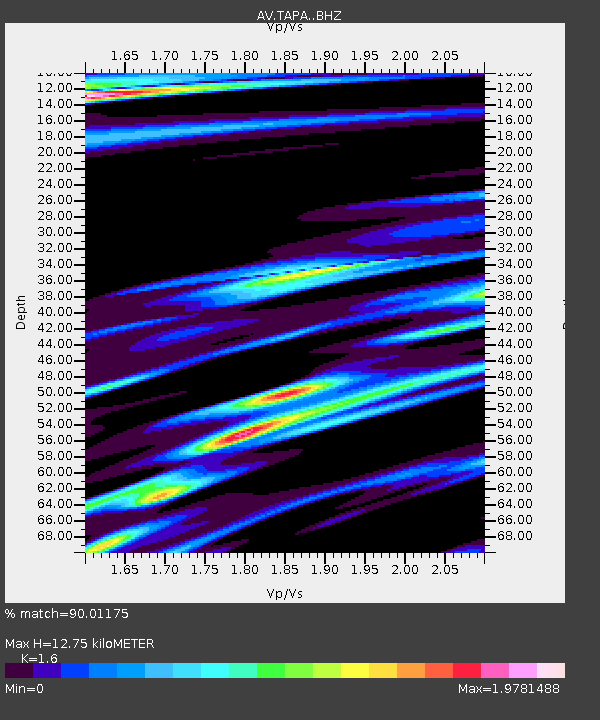
| Estimated Moho Depth: |
12.75 km |
| Estimated Crust Vp/Vs: |
1.60 |
| Assumed Crust Vp: |
5.88 km/s |
| Estimated Crust Vs: |
3.675 km/s |
| Estimated Crust Poisson's Ratio: |
0.18 |
|
| Radial Match: |
90.01175 % |
| Radial Bump: |
392 |
| Transverse Match: |
98.897156 % |
| Transverse Bump: |
90 |
| SOD ConfigId: |
28764291 |
| Insert Time: |
2022-08-16 21:21:01.907 +0000 |
| GWidth: |
2.5 |
| Max Bumps: |
400 |
| Tol: |
0.001 |
|

Signal To Noise
| Channel | StoN | STA | LTA |
| AV:TAPA: :BHZ:20220802T21:21:27.159992Z | 3.557611 | 2.2234476E-6 | 6.249834E-7 |
| AV:TAPA: :BHN:20220802T21:21:27.159992Z | 3.987852 | 5.6258564E-6 | 1.4107485E-6 |
| AV:TAPA: :BHE:20220802T21:21:27.159992Z | 3.501718 | 1.5553247E-6 | 4.441605E-7 |
| Arrivals |
| Ps | 1.3 SECOND |
| PpPs | 5.5 SECOND |
| PsPs/PpSs | 6.8 SECOND |


