You are here: Home > Network List > HL - National Observatory of Athens Digital Broadband Network Stations List
> Station ITM ITHOMI, GREECE > Earthquake Result Viewer
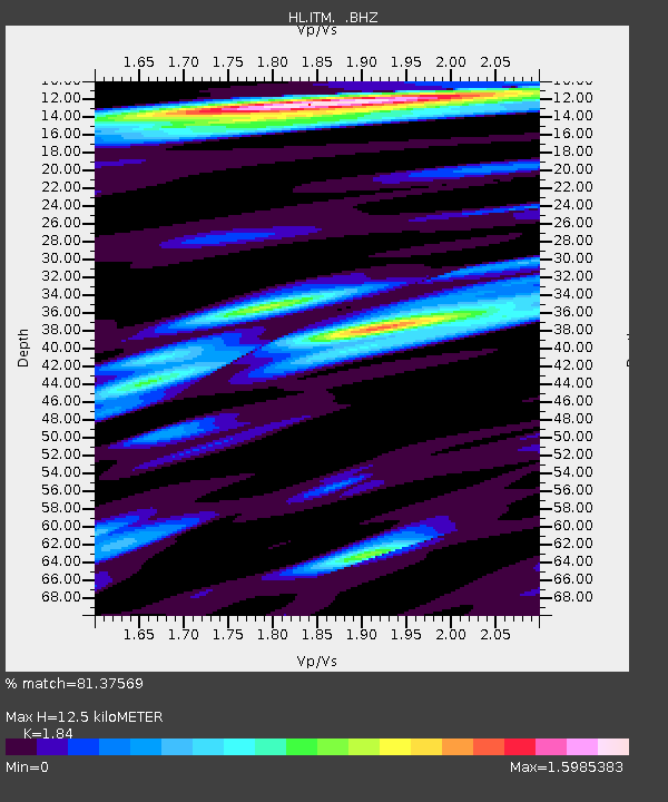
ITM ITHOMI, GREECE - Earthquake Result Viewer
| Earthquake location: |
Hokkaido, Japan Region |
| Earthquake latitude/longitude: |
41.9/143.8 |
| Earthquake time(UTC): |
2008/09/11 (255) 00:20:50 GMT |
| Earthquake Depth: |
25 km |
| Earthquake Magnitude: |
6.1 MB, 7.0 MS, 6.8 MW, 6.8 MW |
| Earthquake Catalog/Contributor: |
WHDF/NEIC |
|
| Network: |
HL National Observatory of Athens Digital Broadband Network |
| Station: |
ITM ITHOMI, GREECE |
| Lat/Lon: |
37.18 N/21.93 E |
| Elevation: |
400 m |
|
| Distance: |
85.1 deg |
| Az: |
317.069 deg |
| Baz: |
39.547 deg |
| Ray Param: |
0.04499528 |
| Estimated Moho Depth: |
12.5 km |
| Estimated Crust Vp/Vs: |
1.84 |
| Assumed Crust Vp: |
5.627 km/s |
| Estimated Crust Vs: |
3.058 km/s |
| Estimated Crust Poisson's Ratio: |
0.29 |
|
| Radial Match: |
81.37569 % |
| Radial Bump: |
358 |
| Transverse Match: |
80.666145 % |
| Transverse Bump: |
400 |
| SOD ConfigId: |
2560 |
| Insert Time: |
2010-03-09 23:23:04.512 +0000 |
| GWidth: |
2.5 |
| Max Bumps: |
400 |
| Tol: |
0.001 |
|

Signal To Noise
| Channel | StoN | STA | LTA |
| HL:ITM: :BHZ:20080911T00:32:53.110002Z | 12.745575 | 5.9222957E-6 | 4.6465505E-7 |
| HL:ITM: :BHN:20080911T00:32:53.110002Z | 1.7549736 | 1.4270453E-6 | 8.1314346E-7 |
| HL:ITM: :BHE:20080911T00:32:53.110002Z | 0.95846987 | 4.699235E-7 | 4.902851E-7 |
| Arrivals |
| Ps | 1.9 SECOND |
| PpPs | 6.2 SECOND |
| PsPs/PpSs | 8.1 SECOND |


