You are here: Home > Network List > AG - Arkansas Seismic Network Stations List
> Station X40A Basin Creek Farm, Marlvern, AR > Earthquake Result Viewer
X40A Basin Creek Farm, Marlvern, AR - Earthquake Result Viewer
| Earthquake location: |
Peru-Brazil Border Region |
| Earthquake latitude/longitude: |
-11.0/-70.8 |
| Earthquake time(UTC): |
2018/08/24 (236) 09:04:06 GMT |
| Earthquake Depth: |
609 km |
| Earthquake Magnitude: |
7.1 Mww |
| Earthquake Catalog/Contributor: |
NEIC PDE/us |
|
| Network: |
AG Arkansas Seismic Network |
| Station: |
X40A Basin Creek Farm, Marlvern, AR |
| Lat/Lon: |
34.49 N/92.83 W |
| Elevation: |
158 m |
|
| Distance: |
49.9 deg |
| Az: |
336.108 deg |
| Baz: |
151.226 deg |
| Ray Param: |
0.06554232 |
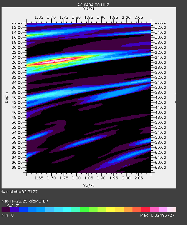
| Estimated Moho Depth: |
25.25 km |
| Estimated Crust Vp/Vs: |
1.71 |
| Assumed Crust Vp: |
6.498 km/s |
| Estimated Crust Vs: |
3.8 km/s |
| Estimated Crust Poisson's Ratio: |
0.24 |
|
| Radial Match: |
82.3127 % |
| Radial Bump: |
400 |
| Transverse Match: |
74.14722 % |
| Transverse Bump: |
400 |
| SOD ConfigId: |
2825771 |
| Insert Time: |
2018-09-07 09:11:04.339 +0000 |
| GWidth: |
2.5 |
| Max Bumps: |
400 |
| Tol: |
0.001 |
|
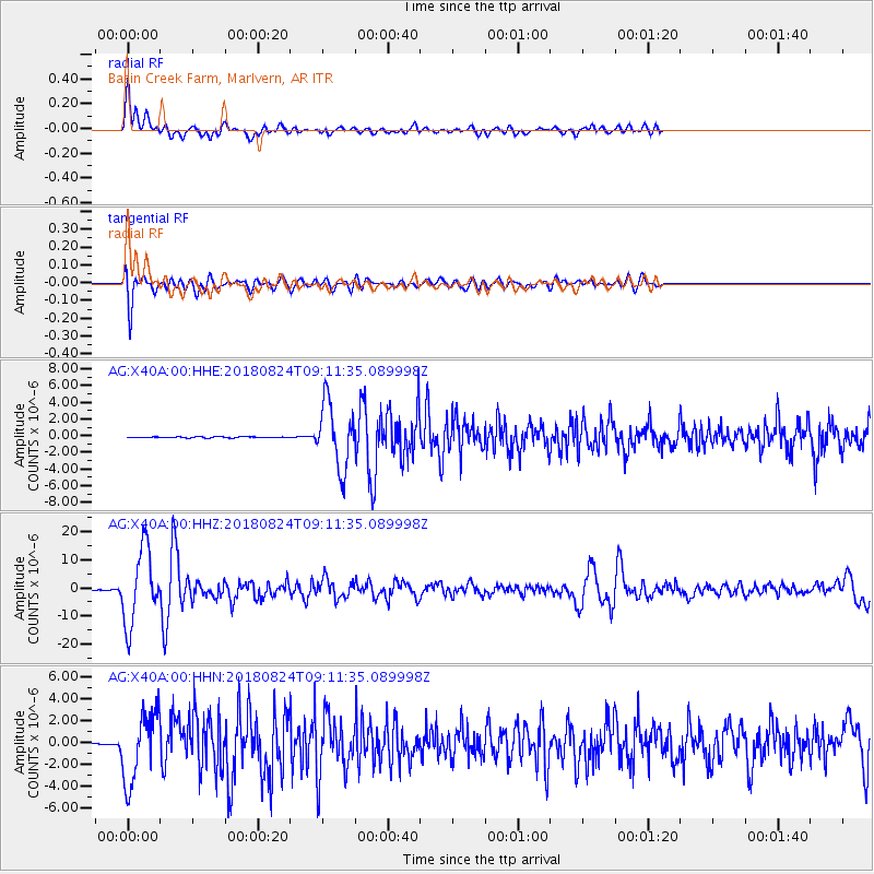
Signal To Noise
| Channel | StoN | STA | LTA |
| AG:X40A:00:HHZ:20180824T09:11:35.089998Z | 160.73186 | 1.3210313E-5 | 8.218852E-8 |
| AG:X40A:00:HHN:20180824T09:11:35.089998Z | 54.23234 | 3.2178705E-6 | 5.9334898E-8 |
| AG:X40A:00:HHE:20180824T09:11:35.089998Z | 62.15059 | 3.866849E-6 | 6.221742E-8 |
| Arrivals |
| Ps | 2.9 SECOND |
| PpPs | 10.0 SECOND |
| PsPs/PpSs | 13 SECOND |


