You are here: Home > Network List > US - United States National Seismic Network Stations List
> Station AMTX Amarillo, Texas, USA > Earthquake Result Viewer
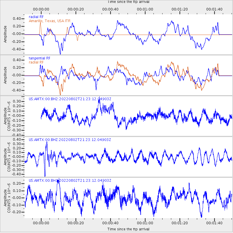
AMTX Amarillo, Texas, USA - Earthquake Result Viewer
*The percent match for this event was below the threshold and hence no stack was calculated.
| Earthquake location: |
Fiji Islands Region |
| Earthquake latitude/longitude: |
-18.1/-178.2 |
| Earthquake time(UTC): |
2022/08/02 (214) 21:11:41 GMT |
| Earthquake Depth: |
521 km |
| Earthquake Magnitude: |
5.6 Mww |
| Earthquake Catalog/Contributor: |
NEIC PDE/us |
|
| Network: |
US United States National Seismic Network |
| Station: |
AMTX Amarillo, Texas, USA |
| Lat/Lon: |
34.53 N/101.41 W |
| Elevation: |
1010 m |
|
| Distance: |
89.7 deg |
| Az: |
53.492 deg |
| Baz: |
247.805 deg |
| Ray Param: |
$rayparam |
*The percent match for this event was below the threshold and hence was not used in the summary stack. |
|
| Radial Match: |
32.54025 % |
| Radial Bump: |
400 |
| Transverse Match: |
45.1585 % |
| Transverse Bump: |
400 |
| SOD ConfigId: |
28764291 |
| Insert Time: |
2022-08-16 21:38:35.750 +0000 |
| GWidth: |
2.5 |
| Max Bumps: |
400 |
| Tol: |
0.001 |
|
Signal To Noise
| Channel | StoN | STA | LTA |
| US:AMTX:00:BHZ:20220802T21:23:12.04903Z | 2.5847192 | 1.8489229E-7 | 7.153283E-8 |
| US:AMTX:00:BH1:20220802T21:23:12.04903Z | 0.6273726 | 6.2651964E-8 | 9.986403E-8 |
| US:AMTX:00:BH2:20220802T21:23:12.04903Z | 1.6546538 | 1.574475E-7 | 9.515435E-8 |
| Arrivals |
| Ps | |
| PpPs | |
| PsPs/PpSs | |


