You are here: Home > Network List > US - United States National Seismic Network Stations List
> Station MNTX Cornudas Mountains, Texas, USA > Earthquake Result Viewer
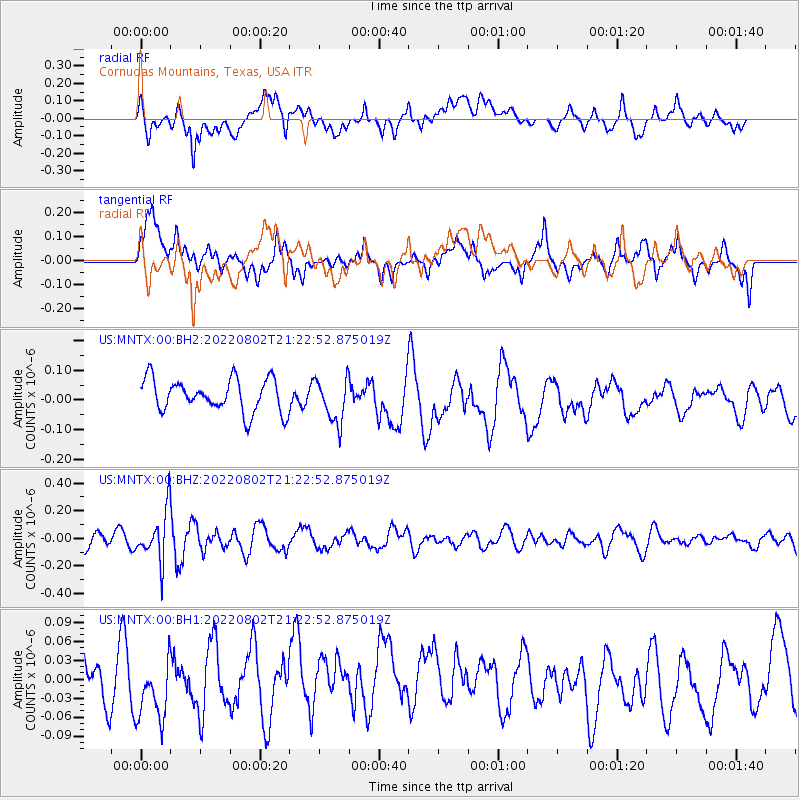
MNTX Cornudas Mountains, Texas, USA - Earthquake Result Viewer
*The percent match for this event was below the threshold and hence no stack was calculated.
| Earthquake location: |
Fiji Islands Region |
| Earthquake latitude/longitude: |
-18.1/-178.2 |
| Earthquake time(UTC): |
2022/08/02 (214) 21:11:41 GMT |
| Earthquake Depth: |
521 km |
| Earthquake Magnitude: |
5.6 Mww |
| Earthquake Catalog/Contributor: |
NEIC PDE/us |
|
| Network: |
US United States National Seismic Network |
| Station: |
MNTX Cornudas Mountains, Texas, USA |
| Lat/Lon: |
31.70 N/105.38 W |
| Elevation: |
405 m |
|
| Distance: |
85.5 deg |
| Az: |
54.77 deg |
| Baz: |
245.696 deg |
| Ray Param: |
$rayparam |
*The percent match for this event was below the threshold and hence was not used in the summary stack. |
|
| Radial Match: |
54.827904 % |
| Radial Bump: |
400 |
| Transverse Match: |
58.442722 % |
| Transverse Bump: |
400 |
| SOD ConfigId: |
28764291 |
| Insert Time: |
2022-08-16 21:38:58.961 +0000 |
| GWidth: |
2.5 |
| Max Bumps: |
400 |
| Tol: |
0.001 |
|
Signal To Noise
| Channel | StoN | STA | LTA |
| US:MNTX:00:BHZ:20220802T21:22:52.875019Z | 2.2697861 | 1.8460902E-7 | 8.1333226E-8 |
| US:MNTX:00:BH1:20220802T21:22:52.875019Z | 1.2993536 | 4.8551254E-8 | 3.7365698E-8 |
| US:MNTX:00:BH2:20220802T21:22:52.875019Z | 1.3667651 | 7.5292135E-8 | 5.5087835E-8 |
| Arrivals |
| Ps | |
| PpPs | |
| PsPs/PpSs | |


