You are here: Home > Network List > GS - US Geological Survey Networks Stations List
> Station NE02 NE02 Southeast of Arnold, NE > Earthquake Result Viewer
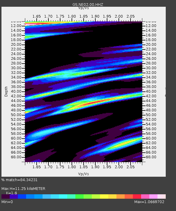
NE02 NE02 Southeast of Arnold, NE - Earthquake Result Viewer
| Earthquake location: |
Peru-Brazil Border Region |
| Earthquake latitude/longitude: |
-11.0/-70.8 |
| Earthquake time(UTC): |
2018/08/24 (236) 09:04:06 GMT |
| Earthquake Depth: |
609 km |
| Earthquake Magnitude: |
7.1 Mww |
| Earthquake Catalog/Contributor: |
NEIC PDE/us |
|
| Network: |
GS US Geological Survey Networks |
| Station: |
NE02 NE02 Southeast of Arnold, NE |
| Lat/Lon: |
41.35 N/100.09 W |
| Elevation: |
817 m |
|
| Distance: |
58.7 deg |
| Az: |
334.48 deg |
| Baz: |
145.82 deg |
| Ray Param: |
0.060145456 |
| Estimated Moho Depth: |
11.25 km |
| Estimated Crust Vp/Vs: |
1.60 |
| Assumed Crust Vp: |
6.483 km/s |
| Estimated Crust Vs: |
4.052 km/s |
| Estimated Crust Poisson's Ratio: |
0.18 |
|
| Radial Match: |
84.34231 % |
| Radial Bump: |
400 |
| Transverse Match: |
74.30342 % |
| Transverse Bump: |
400 |
| SOD ConfigId: |
2825771 |
| Insert Time: |
2018-09-07 09:13:48.957 +0000 |
| GWidth: |
2.5 |
| Max Bumps: |
400 |
| Tol: |
0.001 |
|

Signal To Noise
| Channel | StoN | STA | LTA |
| GS:NE02:00:HHZ:20180824T09:12:36.648011Z | 160.49374 | 1.8848314E-5 | 1.17439555E-7 |
| GS:NE02:00:HH1:20180824T09:12:36.648011Z | 36.921562 | 1.1917769E-5 | 3.2278615E-7 |
| GS:NE02:00:HH2:20180824T09:12:36.648011Z | 28.548395 | 1.0185915E-5 | 3.567947E-7 |
| Arrivals |
| Ps | 1.1 SECOND |
| PpPs | 4.3 SECOND |
| PsPs/PpSs | 5.4 SECOND |


