You are here: Home > Network List > UW - Pacific Northwest Regional Seismic Network Stations List
> Station UMAT Pilot Rock, OR, USA > Earthquake Result Viewer
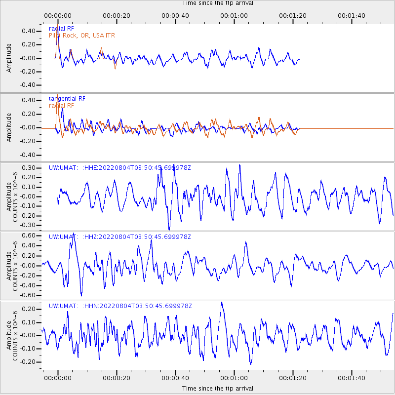
UMAT Pilot Rock, OR, USA - Earthquake Result Viewer
*The percent match for this event was below the threshold and hence no stack was calculated.
| Earthquake location: |
Southeast Of Honshu, Japan |
| Earthquake latitude/longitude: |
32.6/142.5 |
| Earthquake time(UTC): |
2022/08/04 (216) 03:39:46 GMT |
| Earthquake Depth: |
10 km |
| Earthquake Magnitude: |
5.7 mww |
| Earthquake Catalog/Contributor: |
NEIC PDE/us |
|
| Network: |
UW Pacific Northwest Regional Seismic Network |
| Station: |
UMAT Pilot Rock, OR, USA |
| Lat/Lon: |
45.29 N/118.96 W |
| Elevation: |
1318 m |
|
| Distance: |
73.0 deg |
| Az: |
46.863 deg |
| Baz: |
299.289 deg |
| Ray Param: |
$rayparam |
*The percent match for this event was below the threshold and hence was not used in the summary stack. |
|
| Radial Match: |
74.51254 % |
| Radial Bump: |
394 |
| Transverse Match: |
49.816116 % |
| Transverse Bump: |
398 |
| SOD ConfigId: |
28764291 |
| Insert Time: |
2022-08-18 04:11:42.182 +0000 |
| GWidth: |
2.5 |
| Max Bumps: |
400 |
| Tol: |
0.001 |
|
Signal To Noise
| Channel | StoN | STA | LTA |
| UW:UMAT: :HHZ:20220804T03:50:45.699978Z | 2.0782902 | 2.4153294E-7 | 1.1621714E-7 |
| UW:UMAT: :HHN:20220804T03:50:45.699978Z | 0.81734604 | 6.593175E-8 | 8.066565E-8 |
| UW:UMAT: :HHE:20220804T03:50:45.699978Z | 1.1807957 | 9.89852E-8 | 8.3829235E-8 |
| Arrivals |
| Ps | |
| PpPs | |
| PsPs/PpSs | |


