You are here: Home > Network List > IU - Global Seismograph Network (GSN - IRIS/USGS) Stations List
> Station RSSD Black Hills, South Dakota, USA > Earthquake Result Viewer
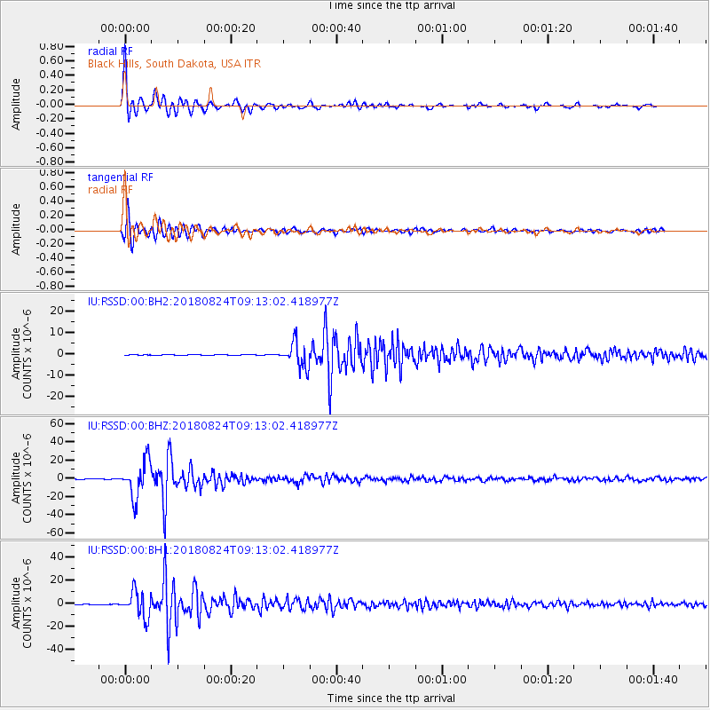
RSSD Black Hills, South Dakota, USA - Earthquake Result Viewer
*The percent match for this event was below the threshold and hence no stack was calculated.
| Earthquake location: |
Peru-Brazil Border Region |
| Earthquake latitude/longitude: |
-11.0/-70.8 |
| Earthquake time(UTC): |
2018/08/24 (236) 09:04:06 GMT |
| Earthquake Depth: |
609 km |
| Earthquake Magnitude: |
7.1 Mww |
| Earthquake Catalog/Contributor: |
NEIC PDE/us |
|
| Network: |
IU Global Seismograph Network (GSN - IRIS/USGS) |
| Station: |
RSSD Black Hills, South Dakota, USA |
| Lat/Lon: |
44.12 N/104.04 W |
| Elevation: |
2090 m |
|
| Distance: |
62.6 deg |
| Az: |
333.626 deg |
| Baz: |
142.733 deg |
| Ray Param: |
$rayparam |
*The percent match for this event was below the threshold and hence was not used in the summary stack. |
|
| Radial Match: |
97.998505 % |
| Radial Bump: |
400 |
| Transverse Match: |
95.50572 % |
| Transverse Bump: |
400 |
| SOD ConfigId: |
2825771 |
| Insert Time: |
2018-09-07 09:14:36.702 +0000 |
| GWidth: |
2.5 |
| Max Bumps: |
400 |
| Tol: |
0.001 |
|
Signal To Noise
| Channel | StoN | STA | LTA |
| IU:RSSD:00:BHZ:20180824T09:13:02.418977Z | 181.4025 | 1.9917581E-5 | 1.0979772E-7 |
| IU:RSSD:00:BH1:20180824T09:13:02.418977Z | 149.26729 | 1.1234501E-5 | 7.5264325E-8 |
| IU:RSSD:00:BH2:20180824T09:13:02.418977Z | 78.87842 | 5.9250187E-6 | 7.511584E-8 |
| Arrivals |
| Ps | |
| PpPs | |
| PsPs/PpSs | |


