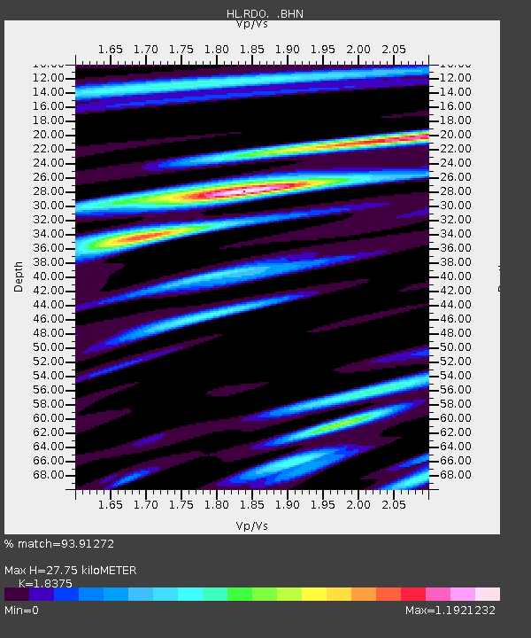
RDO RODHOPI, GREECE - Earthquake Result Viewer

Earthquake location: Off W Coast Of Northern Sumatra
Earthquake latitude/longitude: 2.8/96.0
Earthquake time(UTC): 2008/02/20 (051) 08:08:30 GMT
Earthquake Depth: 26 km
Earthquake Magnitude: 6.5 MB, 7.5 MS, 7.4 MW, 7.4 MW
Earthquake Catalog/Contributor: WHDF/NEIC
Network: HL National Observatory of Athens Digital Broadband Network
Station: RDO RODHOPI, GREECE
Lat/Lon: 41.15 N/25.54 E
Elevation: 100 m
Distance: 73.5 deg
Az: 312.083 deg
Baz: 101.011 deg
Ray Param: 0.05293613
Estimated Moho Depth: 27.75 km
Estimated Crust Vp/Vs: 1.84
Assumed Crust Vp: 6.279 km/s
Estimated Crust Vs: 3.417 km/s
Estimated Crust Poisson's Ratio: 0.29
Radial Match: 93.91272 %
Radial Bump: 400
Transverse Match: 80.52645 %
Transverse Bump: 400
SOD ConfigId: 2564
Insert Time: 2010-03-09 23:28:52.994 +0000
GWidth: 2.5
Max Bumps: 400
Tol: 0.001

Signal To Noise

ChannelStoNSTALTA
HL:RDO: :BHN:20080220T08:19:29.629009Z1.33745852.7213522E-72.034719E-7
HL:RDO: :BHE:20080220T08:19:29.629009Z2.77300294.8527426E-71.7499954E-7
HL:RDO: :BHZ:20080220T08:19:29.629009Z10.655551.6121874E-61.5130026E-7
Arrivals
Ps3.8 SECOND
PpPs12 SECOND
PsPs/PpSs16 SECOND