You are here: Home > Network List > NE - New England Seismic Network Stations List
> Station WES Weston Observatory, Weston, MA, USA > Earthquake Result Viewer
WES Weston Observatory, Weston, MA, USA - Earthquake Result Viewer
| Earthquake location: |
Peru-Brazil Border Region |
| Earthquake latitude/longitude: |
-11.0/-70.8 |
| Earthquake time(UTC): |
2018/08/24 (236) 09:04:06 GMT |
| Earthquake Depth: |
609 km |
| Earthquake Magnitude: |
7.1 Mww |
| Earthquake Catalog/Contributor: |
NEIC PDE/us |
|
| Network: |
NE New England Seismic Network |
| Station: |
WES Weston Observatory, Weston, MA, USA |
| Lat/Lon: |
42.38 N/71.32 W |
| Elevation: |
60 m |
|
| Distance: |
53.2 deg |
| Az: |
359.533 deg |
| Baz: |
179.381 deg |
| Ray Param: |
0.06353829 |
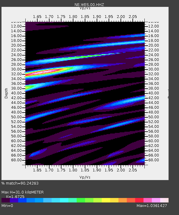
| Estimated Moho Depth: |
31.0 km |
| Estimated Crust Vp/Vs: |
1.67 |
| Assumed Crust Vp: |
6.419 km/s |
| Estimated Crust Vs: |
3.838 km/s |
| Estimated Crust Poisson's Ratio: |
0.22 |
|
| Radial Match: |
90.24263 % |
| Radial Bump: |
400 |
| Transverse Match: |
72.2616 % |
| Transverse Bump: |
400 |
| SOD ConfigId: |
2825771 |
| Insert Time: |
2018-09-07 09:15:51.985 +0000 |
| GWidth: |
2.5 |
| Max Bumps: |
400 |
| Tol: |
0.001 |
|

Signal To Noise
| Channel | StoN | STA | LTA |
| NE:WES:00:HHZ:20180824T09:11:58.674012Z | 63.987736 | 1.0704507E-5 | 1.6728998E-7 |
| NE:WES:00:HH1:20180824T09:11:58.674012Z | 44.780083 | 5.915185E-6 | 1.320941E-7 |
| NE:WES:00:HH2:20180824T09:11:58.674012Z | 4.7217627 | 7.919769E-7 | 1.6772908E-7 |
| Arrivals |
| Ps | 3.4 SECOND |
| PpPs | 12 SECOND |
| PsPs/PpSs | 16 SECOND |


