You are here: Home > Network List > AG - Arkansas Seismic Network Stations List
> Station U40A Yellville, AR > Earthquake Result Viewer
U40A Yellville, AR - Earthquake Result Viewer
| Earthquake location: |
East Of Kuril Islands |
| Earthquake latitude/longitude: |
43.8/148.2 |
| Earthquake time(UTC): |
2022/08/07 (219) 13:40:36 GMT |
| Earthquake Depth: |
10 km |
| Earthquake Magnitude: |
6.1 mww |
| Earthquake Catalog/Contributor: |
NEIC PDE/us |
|
| Network: |
AG Arkansas Seismic Network |
| Station: |
U40A Yellville, AR |
| Lat/Lon: |
36.36 N/92.85 W |
| Elevation: |
374 m |
|
| Distance: |
82.9 deg |
| Az: |
45.378 deg |
| Baz: |
320.317 deg |
| Ray Param: |
0.046583913 |
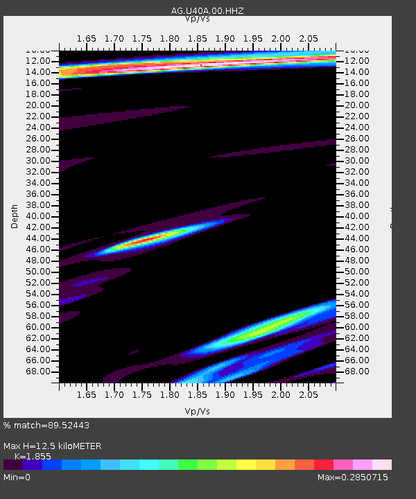
| Estimated Moho Depth: |
12.5 km |
| Estimated Crust Vp/Vs: |
1.86 |
| Assumed Crust Vp: |
6.53 km/s |
| Estimated Crust Vs: |
3.52 km/s |
| Estimated Crust Poisson's Ratio: |
0.30 |
|
| Radial Match: |
89.52443 % |
| Radial Bump: |
400 |
| Transverse Match: |
72.806404 % |
| Transverse Bump: |
400 |
| SOD ConfigId: |
28764291 |
| Insert Time: |
2022-08-21 13:43:31.280 +0000 |
| GWidth: |
2.5 |
| Max Bumps: |
400 |
| Tol: |
0.001 |
|
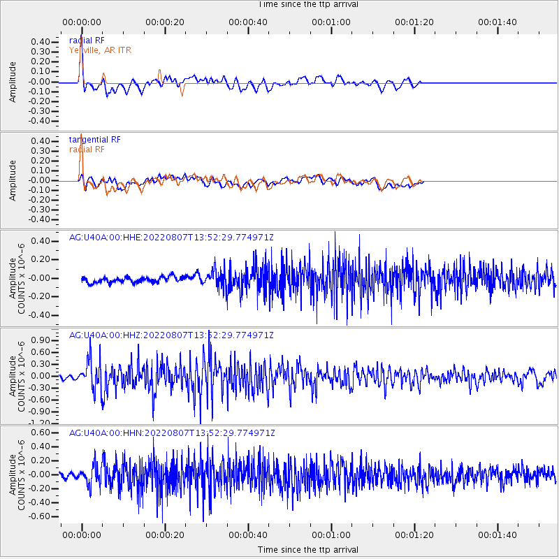
Signal To Noise
| Channel | StoN | STA | LTA |
| AG:U40A:00:HHZ:20220807T13:52:29.774971Z | 8.969485 | 3.793508E-7 | 4.2293482E-8 |
| AG:U40A:00:HHN:20220807T13:52:29.774971Z | 3.676858 | 1.3371583E-7 | 3.6366874E-8 |
| AG:U40A:00:HHE:20220807T13:52:29.774971Z | 2.9252243 | 8.8980094E-8 | 3.041821E-8 |
| Arrivals |
| Ps | 1.7 SECOND |
| PpPs | 5.3 SECOND |
| PsPs/PpSs | 7.0 SECOND |


