You are here: Home > Network List > AK - Alaska Regional Network Stations List
> Station H16K Elim, AK, USA > Earthquake Result Viewer
H16K Elim, AK, USA - Earthquake Result Viewer
| Earthquake location: |
East Of Kuril Islands |
| Earthquake latitude/longitude: |
43.8/148.2 |
| Earthquake time(UTC): |
2022/08/07 (219) 13:40:36 GMT |
| Earthquake Depth: |
10 km |
| Earthquake Magnitude: |
6.1 mww |
| Earthquake Catalog/Contributor: |
NEIC PDE/us |
|
| Network: |
AK Alaska Regional Network |
| Station: |
H16K Elim, AK, USA |
| Lat/Lon: |
64.64 N/162.24 W |
| Elevation: |
216 m |
|
| Distance: |
34.5 deg |
| Az: |
35.421 deg |
| Baz: |
257.049 deg |
| Ray Param: |
0.077739075 |
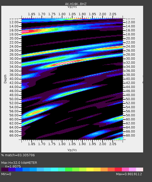
| Estimated Moho Depth: |
32.0 km |
| Estimated Crust Vp/Vs: |
1.81 |
| Assumed Crust Vp: |
6.276 km/s |
| Estimated Crust Vs: |
3.472 km/s |
| Estimated Crust Poisson's Ratio: |
0.28 |
|
| Radial Match: |
83.305786 % |
| Radial Bump: |
400 |
| Transverse Match: |
58.280437 % |
| Transverse Bump: |
400 |
| SOD ConfigId: |
28764291 |
| Insert Time: |
2022-08-21 13:45:12.558 +0000 |
| GWidth: |
2.5 |
| Max Bumps: |
400 |
| Tol: |
0.001 |
|

Signal To Noise
| Channel | StoN | STA | LTA |
| AK:H16K: :BHZ:20220807T13:46:53.539985Z | 10.870937 | 1.1527828E-6 | 1.0604263E-7 |
| AK:H16K: :BHN:20220807T13:46:53.539985Z | 2.1239078 | 2.0619754E-7 | 9.708403E-8 |
| AK:H16K: :BHE:20220807T13:46:53.539985Z | 5.3709407 | 6.0190536E-7 | 1.1206702E-7 |
| Arrivals |
| Ps | 4.4 SECOND |
| PpPs | 13 SECOND |
| PsPs/PpSs | 18 SECOND |


