You are here: Home > Network List > AK - Alaska Regional Network Stations List
> Station N18K Kilae Creek, AK, USA > Earthquake Result Viewer
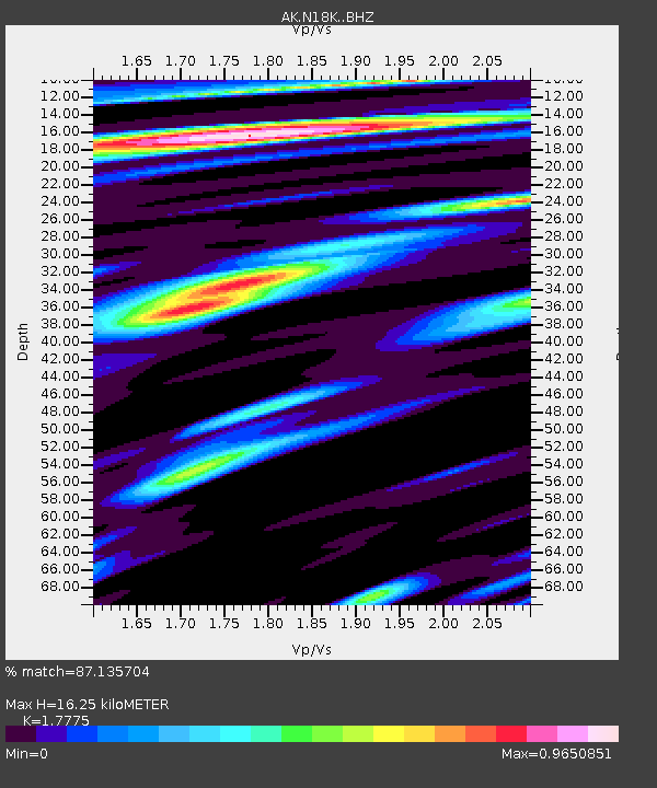
N18K Kilae Creek, AK, USA - Earthquake Result Viewer
| Earthquake location: |
East Of Kuril Islands |
| Earthquake latitude/longitude: |
43.8/148.2 |
| Earthquake time(UTC): |
2022/08/07 (219) 13:40:36 GMT |
| Earthquake Depth: |
10 km |
| Earthquake Magnitude: |
6.1 mww |
| Earthquake Catalog/Contributor: |
NEIC PDE/us |
|
| Network: |
AK Alaska Regional Network |
| Station: |
N18K Kilae Creek, AK, USA |
| Lat/Lon: |
60.68 N/155.89 W |
| Elevation: |
572 m |
|
| Distance: |
36.9 deg |
| Az: |
42.801 deg |
| Baz: |
268.685 deg |
| Ray Param: |
0.076471135 |
| Estimated Moho Depth: |
16.25 km |
| Estimated Crust Vp/Vs: |
1.78 |
| Assumed Crust Vp: |
6.566 km/s |
| Estimated Crust Vs: |
3.694 km/s |
| Estimated Crust Poisson's Ratio: |
0.27 |
|
| Radial Match: |
87.135704 % |
| Radial Bump: |
370 |
| Transverse Match: |
70.20232 % |
| Transverse Bump: |
400 |
| SOD ConfigId: |
28764291 |
| Insert Time: |
2022-08-21 13:46:30.462 +0000 |
| GWidth: |
2.5 |
| Max Bumps: |
400 |
| Tol: |
0.001 |
|

Signal To Noise
| Channel | StoN | STA | LTA |
| AK:N18K: :BHZ:20220807T13:47:14.259987Z | 14.693754 | 7.7430525E-7 | 5.2696212E-8 |
| AK:N18K: :BHN:20220807T13:47:14.259987Z | 1.1301248 | 7.5567385E-8 | 6.6866406E-8 |
| AK:N18K: :BHE:20220807T13:47:14.259987Z | 6.4804826 | 3.9507702E-7 | 6.096414E-8 |
| Arrivals |
| Ps | 2.1 SECOND |
| PpPs | 6.4 SECOND |
| PsPs/PpSs | 8.4 SECOND |


