You are here: Home > Network List > AK - Alaska Regional Network Stations List
> Station PS06 TAPS Pump Station 6, AK, USA > Earthquake Result Viewer
PS06 TAPS Pump Station 6, AK, USA - Earthquake Result Viewer
| Earthquake location: |
East Of Kuril Islands |
| Earthquake latitude/longitude: |
43.8/148.2 |
| Earthquake time(UTC): |
2022/08/07 (219) 13:40:36 GMT |
| Earthquake Depth: |
10 km |
| Earthquake Magnitude: |
6.1 mww |
| Earthquake Catalog/Contributor: |
NEIC PDE/us |
|
| Network: |
AK Alaska Regional Network |
| Station: |
PS06 TAPS Pump Station 6, AK, USA |
| Lat/Lon: |
65.85 N/149.74 W |
| Elevation: |
280 m |
|
| Distance: |
39.8 deg |
| Az: |
34.58 deg |
| Baz: |
267.726 deg |
| Ray Param: |
0.07475985 |
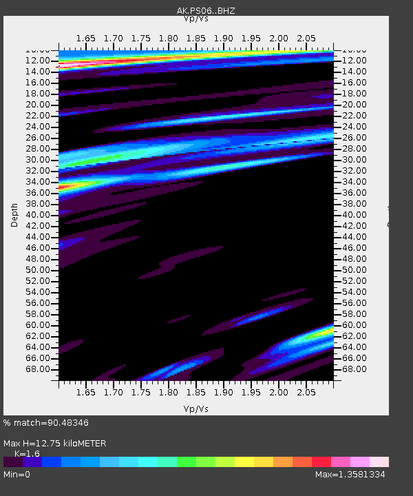
| Estimated Moho Depth: |
12.75 km |
| Estimated Crust Vp/Vs: |
1.60 |
| Assumed Crust Vp: |
6.566 km/s |
| Estimated Crust Vs: |
4.104 km/s |
| Estimated Crust Poisson's Ratio: |
0.18 |
|
| Radial Match: |
90.48346 % |
| Radial Bump: |
400 |
| Transverse Match: |
69.50265 % |
| Transverse Bump: |
400 |
| SOD ConfigId: |
28764291 |
| Insert Time: |
2022-08-21 13:46:52.748 +0000 |
| GWidth: |
2.5 |
| Max Bumps: |
400 |
| Tol: |
0.001 |
|

Signal To Noise
| Channel | StoN | STA | LTA |
| AK:PS06: :BHZ:20220807T13:47:39.048011Z | 18.058147 | 6.306677E-7 | 3.4924277E-8 |
| AK:PS06: :BHN:20220807T13:47:39.048011Z | 2.4338834 | 1.3319553E-7 | 5.4725515E-8 |
| AK:PS06: :BHE:20220807T13:47:39.048011Z | 8.670975 | 6.43846E-7 | 7.425301E-8 |
| Arrivals |
| Ps | 1.3 SECOND |
| PpPs | 4.6 SECOND |
| PsPs/PpSs | 5.9 SECOND |


