You are here: Home > Network List > TX - Texas Seismological Network Stations List
> Station FW14 Alvarado > Earthquake Result Viewer
FW14 Alvarado - Earthquake Result Viewer
| Earthquake location: |
Peru-Brazil Border Region |
| Earthquake latitude/longitude: |
-11.0/-70.8 |
| Earthquake time(UTC): |
2018/08/24 (236) 09:04:06 GMT |
| Earthquake Depth: |
609 km |
| Earthquake Magnitude: |
7.1 Mww |
| Earthquake Catalog/Contributor: |
NEIC PDE/us |
|
| Network: |
TX Texas Seismological Network |
| Station: |
FW14 Alvarado |
| Lat/Lon: |
32.40 N/97.19 W |
| Elevation: |
219 m |
|
| Distance: |
50.0 deg |
| Az: |
330.628 deg |
| Baz: |
145.306 deg |
| Ray Param: |
0.06545693 |
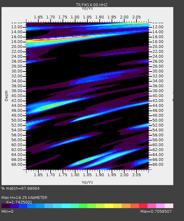
| Estimated Moho Depth: |
16.25 km |
| Estimated Crust Vp/Vs: |
1.74 |
| Assumed Crust Vp: |
6.38 km/s |
| Estimated Crust Vs: |
3.662 km/s |
| Estimated Crust Poisson's Ratio: |
0.25 |
|
| Radial Match: |
87.66864 % |
| Radial Bump: |
400 |
| Transverse Match: |
61.572945 % |
| Transverse Bump: |
400 |
| SOD ConfigId: |
2825771 |
| Insert Time: |
2018-09-07 09:17:32.297 +0000 |
| GWidth: |
2.5 |
| Max Bumps: |
400 |
| Tol: |
0.001 |
|

Signal To Noise
| Channel | StoN | STA | LTA |
| TX:FW14:00:HHZ:20180824T09:11:36.149995Z | 125.98382 | 1.7516497E-5 | 1.3903767E-7 |
| TX:FW14:00:HH1:20180824T09:11:36.149995Z | 39.28899 | 8.036104E-6 | 2.0453834E-7 |
| TX:FW14:00:HH2:20180824T09:11:36.149995Z | 28.78822 | 4.251142E-6 | 1.476695E-7 |
| Arrivals |
| Ps | 2.0 SECOND |
| PpPs | 6.6 SECOND |
| PsPs/PpSs | 8.6 SECOND |


