You are here: Home > Network List > CC - Cascade Chain Volcano Monitoring Stations List
> Station HOA Hoala > Earthquake Result Viewer
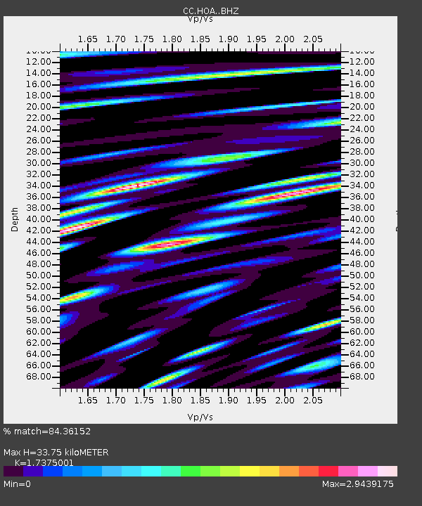
HOA Hoala - Earthquake Result Viewer
| Earthquake location: |
East Of Kuril Islands |
| Earthquake latitude/longitude: |
43.8/148.2 |
| Earthquake time(UTC): |
2022/08/07 (219) 13:40:36 GMT |
| Earthquake Depth: |
10 km |
| Earthquake Magnitude: |
6.1 mww |
| Earthquake Catalog/Contributor: |
NEIC PDE/us |
|
| Network: |
CC Cascade Chain Volcano Monitoring |
| Station: |
HOA Hoala |
| Lat/Lon: |
46.24 N/122.19 W |
| Elevation: |
1151 m |
|
| Distance: |
60.0 deg |
| Az: |
53.25 deg |
| Baz: |
303.272 deg |
| Ray Param: |
0.061802935 |
| Estimated Moho Depth: |
33.75 km |
| Estimated Crust Vp/Vs: |
1.74 |
| Assumed Crust Vp: |
6.566 km/s |
| Estimated Crust Vs: |
3.779 km/s |
| Estimated Crust Poisson's Ratio: |
0.25 |
|
| Radial Match: |
84.36152 % |
| Radial Bump: |
400 |
| Transverse Match: |
78.50719 % |
| Transverse Bump: |
400 |
| SOD ConfigId: |
28764291 |
| Insert Time: |
2022-08-21 13:53:27.645 +0000 |
| GWidth: |
2.5 |
| Max Bumps: |
400 |
| Tol: |
0.001 |
|

Signal To Noise
| Channel | StoN | STA | LTA |
| CC:HOA: :BHZ:20220807T13:50:12.219978Z | 13.033983 | 1.3503216E-6 | 1.0360007E-7 |
| CC:HOA: :BHN:20220807T13:50:12.219978Z | 2.0864217 | 3.7781484E-7 | 1.810827E-7 |
| CC:HOA: :BHE:20220807T13:50:12.219978Z | 3.183578 | 7.0900194E-7 | 2.22706E-7 |
| Arrivals |
| Ps | 4.0 SECOND |
| PpPs | 13 SECOND |
| PsPs/PpSs | 17 SECOND |


