You are here: Home > Network List > TX - Texas Seismological Network Stations List
> Station SN05 Snyder 5 > Earthquake Result Viewer
SN05 Snyder 5 - Earthquake Result Viewer
| Earthquake location: |
Peru-Brazil Border Region |
| Earthquake latitude/longitude: |
-11.0/-70.8 |
| Earthquake time(UTC): |
2018/08/24 (236) 09:04:06 GMT |
| Earthquake Depth: |
609 km |
| Earthquake Magnitude: |
7.1 Mww |
| Earthquake Catalog/Contributor: |
NEIC PDE/us |
|
| Network: |
TX Texas Seismological Network |
| Station: |
SN05 Snyder 5 |
| Lat/Lon: |
32.88 N/100.88 W |
| Elevation: |
724 m |
|
| Distance: |
52.3 deg |
| Az: |
327.781 deg |
| Baz: |
141.537 deg |
| Ray Param: |
0.06409263 |
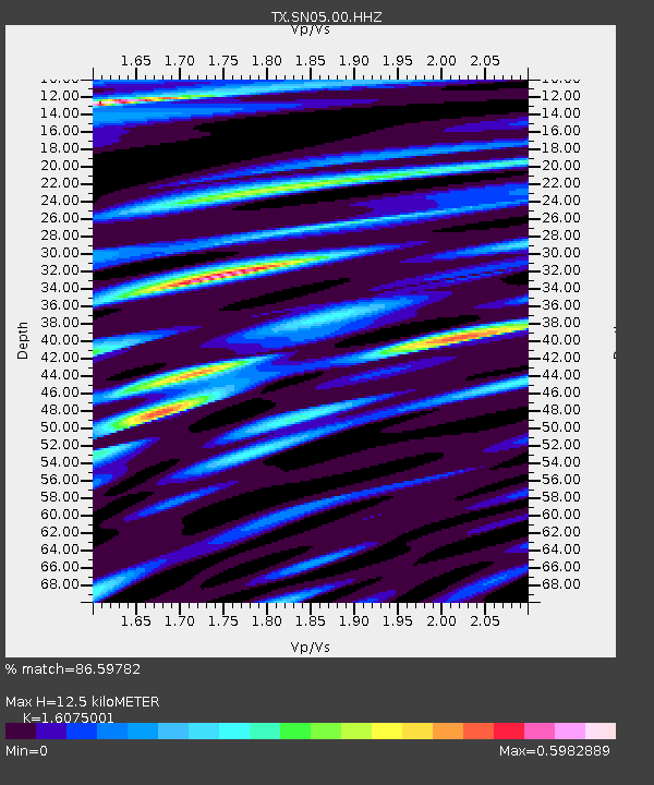
| Estimated Moho Depth: |
12.5 km |
| Estimated Crust Vp/Vs: |
1.61 |
| Assumed Crust Vp: |
6.426 km/s |
| Estimated Crust Vs: |
3.998 km/s |
| Estimated Crust Poisson's Ratio: |
0.18 |
|
| Radial Match: |
86.59782 % |
| Radial Bump: |
390 |
| Transverse Match: |
61.575886 % |
| Transverse Bump: |
400 |
| SOD ConfigId: |
2825771 |
| Insert Time: |
2018-09-07 09:18:03.956 +0000 |
| GWidth: |
2.5 |
| Max Bumps: |
400 |
| Tol: |
0.001 |
|

Signal To Noise
| Channel | StoN | STA | LTA |
| TX:SN05:00:HHZ:20180824T09:11:52.250001Z | 176.9615 | 1.812031E-5 | 1.023969E-7 |
| TX:SN05:00:HH1:20180824T09:11:52.250001Z | 44.64529 | 5.434066E-6 | 1.2171645E-7 |
| TX:SN05:00:HH2:20180824T09:11:52.250001Z | 63.12941 | 5.5308933E-6 | 8.761199E-8 |
| Arrivals |
| Ps | 1.2 SECOND |
| PpPs | 4.8 SECOND |
| PsPs/PpSs | 6.0 SECOND |


