You are here: Home > Network List > TX - Texas Seismological Network Stations List
> Station WTFS Witchita Falls > Earthquake Result Viewer
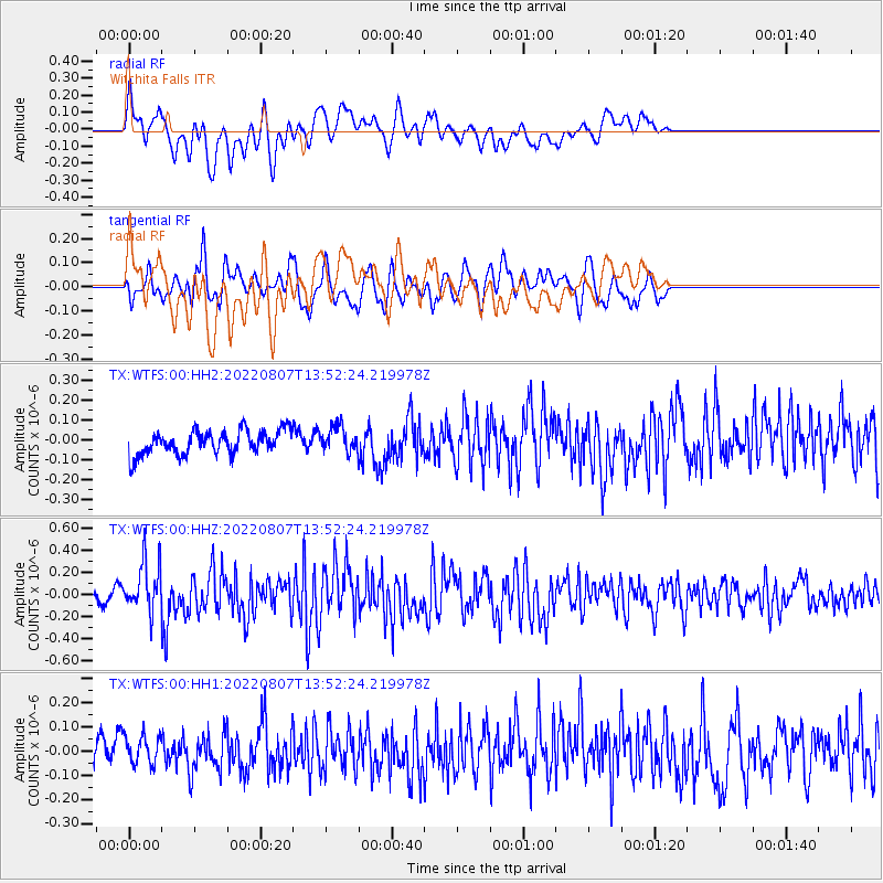
WTFS Witchita Falls - Earthquake Result Viewer
*The percent match for this event was below the threshold and hence no stack was calculated.
| Earthquake location: |
East Of Kuril Islands |
| Earthquake latitude/longitude: |
43.8/148.2 |
| Earthquake time(UTC): |
2022/08/07 (219) 13:40:36 GMT |
| Earthquake Depth: |
10 km |
| Earthquake Magnitude: |
6.1 mww |
| Earthquake Catalog/Contributor: |
NEIC PDE/us |
|
| Network: |
TX Texas Seismological Network |
| Station: |
WTFS Witchita Falls |
| Lat/Lon: |
33.77 N/98.46 W |
| Elevation: |
277 m |
|
| Distance: |
81.8 deg |
| Az: |
50.593 deg |
| Baz: |
317.8 deg |
| Ray Param: |
$rayparam |
*The percent match for this event was below the threshold and hence was not used in the summary stack. |
|
| Radial Match: |
63.1012 % |
| Radial Bump: |
400 |
| Transverse Match: |
54.672733 % |
| Transverse Bump: |
400 |
| SOD ConfigId: |
28764291 |
| Insert Time: |
2022-08-21 14:15:51.214 +0000 |
| GWidth: |
2.5 |
| Max Bumps: |
400 |
| Tol: |
0.001 |
|
Signal To Noise
| Channel | StoN | STA | LTA |
| TX:WTFS:00:HHZ:20220807T13:52:24.219978Z | 5.1430173 | 2.2303286E-7 | 4.336615E-8 |
| TX:WTFS:00:HH1:20220807T13:52:24.219978Z | 1.0369314 | 6.128856E-8 | 5.91057E-8 |
| TX:WTFS:00:HH2:20220807T13:52:24.219978Z | 1.0000906 | 6.144538E-8 | 6.143981E-8 |
| Arrivals |
| Ps | |
| PpPs | |
| PsPs/PpSs | |


