You are here: Home > Network List > US - United States National Seismic Network Stations List
> Station AGMN Agassiz National Wildlife Refuge, Minnesota, USA > Earthquake Result Viewer
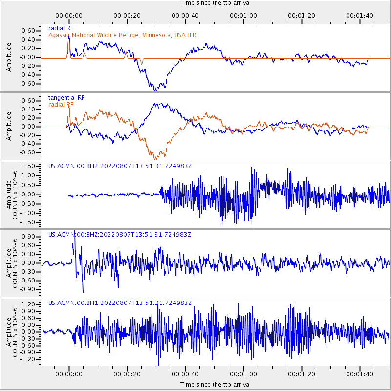
AGMN Agassiz National Wildlife Refuge, Minnesota, USA - Earthquake Result Viewer
*The percent match for this event was below the threshold and hence no stack was calculated.
| Earthquake location: |
East Of Kuril Islands |
| Earthquake latitude/longitude: |
43.8/148.2 |
| Earthquake time(UTC): |
2022/08/07 (219) 13:40:36 GMT |
| Earthquake Depth: |
10 km |
| Earthquake Magnitude: |
6.1 mww |
| Earthquake Catalog/Contributor: |
NEIC PDE/us |
|
| Network: |
US United States National Seismic Network |
| Station: |
AGMN Agassiz National Wildlife Refuge, Minnesota, USA |
| Lat/Lon: |
48.30 N/95.86 W |
| Elevation: |
351 m |
|
| Distance: |
72.4 deg |
| Az: |
39.03 deg |
| Baz: |
316.924 deg |
| Ray Param: |
$rayparam |
*The percent match for this event was below the threshold and hence was not used in the summary stack. |
|
| Radial Match: |
77.814445 % |
| Radial Bump: |
400 |
| Transverse Match: |
73.23514 % |
| Transverse Bump: |
400 |
| SOD ConfigId: |
28764291 |
| Insert Time: |
2022-08-21 14:16:40.972 +0000 |
| GWidth: |
2.5 |
| Max Bumps: |
400 |
| Tol: |
0.001 |
|
Signal To Noise
| Channel | StoN | STA | LTA |
| US:AGMN:00:BHZ:20220807T13:51:31.724983Z | 8.688042 | 4.055831E-7 | 4.6682914E-8 |
| US:AGMN:00:BH1:20220807T13:51:31.724983Z | 4.6034403 | 2.583853E-7 | 5.6128744E-8 |
| US:AGMN:00:BH2:20220807T13:51:31.724983Z | 5.1269016 | 2.411287E-7 | 4.7032053E-8 |
| Arrivals |
| Ps | |
| PpPs | |
| PsPs/PpSs | |


