You are here: Home > Network List > US - United States National Seismic Network Stations List
> Station AMTX Amarillo, Texas, USA > Earthquake Result Viewer
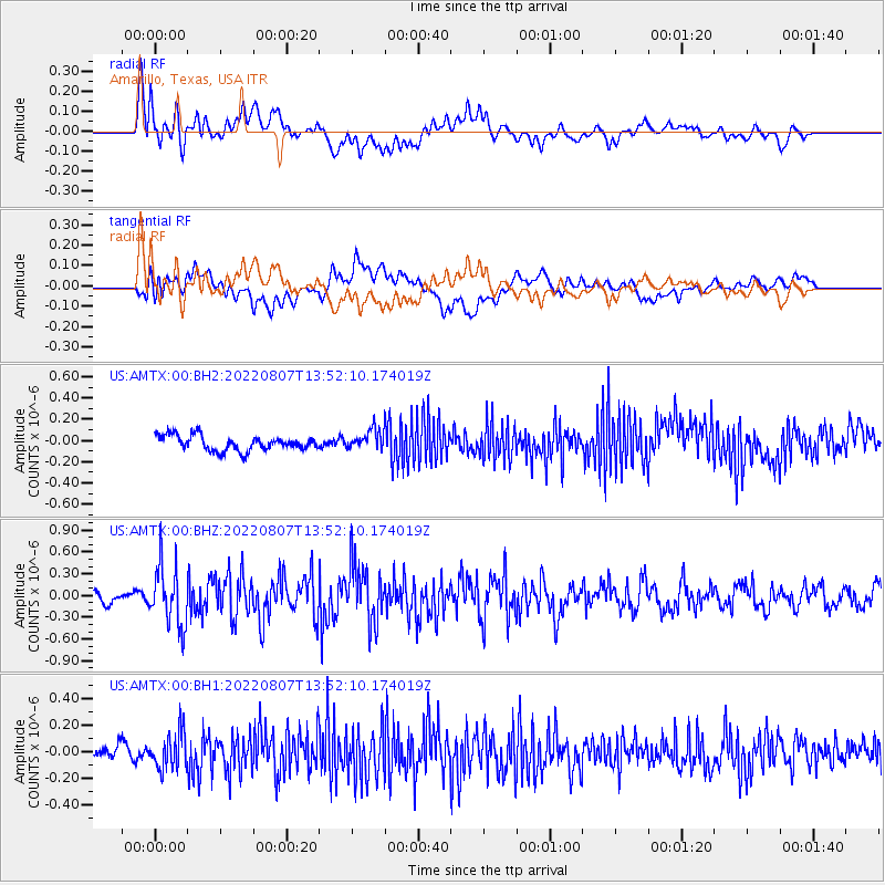
AMTX Amarillo, Texas, USA - Earthquake Result Viewer
*The percent match for this event was below the threshold and hence no stack was calculated.
| Earthquake location: |
East Of Kuril Islands |
| Earthquake latitude/longitude: |
43.8/148.2 |
| Earthquake time(UTC): |
2022/08/07 (219) 13:40:36 GMT |
| Earthquake Depth: |
10 km |
| Earthquake Magnitude: |
6.1 mww |
| Earthquake Catalog/Contributor: |
NEIC PDE/us |
|
| Network: |
US United States National Seismic Network |
| Station: |
AMTX Amarillo, Texas, USA |
| Lat/Lon: |
34.53 N/101.41 W |
| Elevation: |
1010 m |
|
| Distance: |
79.6 deg |
| Az: |
51.879 deg |
| Baz: |
316.363 deg |
| Ray Param: |
$rayparam |
*The percent match for this event was below the threshold and hence was not used in the summary stack. |
|
| Radial Match: |
69.92061 % |
| Radial Bump: |
400 |
| Transverse Match: |
61.580784 % |
| Transverse Bump: |
400 |
| SOD ConfigId: |
28764291 |
| Insert Time: |
2022-08-21 14:16:43.973 +0000 |
| GWidth: |
2.5 |
| Max Bumps: |
400 |
| Tol: |
0.001 |
|
Signal To Noise
| Channel | StoN | STA | LTA |
| US:AMTX:00:BHZ:20220807T13:52:10.174019Z | 5.21502 | 4.0799023E-7 | 7.8233676E-8 |
| US:AMTX:00:BH1:20220807T13:52:10.174019Z | 2.497165 | 1.3388477E-7 | 5.3614706E-8 |
| US:AMTX:00:BH2:20220807T13:52:10.174019Z | 2.4726448 | 1.6223167E-7 | 6.5610585E-8 |
| Arrivals |
| Ps | |
| PpPs | |
| PsPs/PpSs | |


