You are here: Home > Network List > US - United States National Seismic Network Stations List
> Station MSO Missoula, Montana, USA > Earthquake Result Viewer
MSO Missoula, Montana, USA - Earthquake Result Viewer

| Earthquake location: |
Peru-Brazil Border Region |
| Earthquake latitude/longitude: |
-11.0/-70.8 |
| Earthquake time(UTC): |
2018/08/24 (236) 09:04:06 GMT |
| Earthquake Depth: |
609 km |
| Earthquake Magnitude: |
7.1 Mww |
| Earthquake Catalog/Contributor: |
NEIC PDE/us |
|
| Network: |
US United States National Seismic Network |
| Station: |
MSO Missoula, Montana, USA |
| Lat/Lon: |
46.83 N/113.94 W |
| Elevation: |
1264 m |
|
| Distance: |
69.3 deg |
| Az: |
329.882 deg |
| Baz: |
134.156 deg |
| Ray Param: |
0.053580523 |
| Estimated Moho Depth: |
20.5 km |
| Estimated Crust Vp/Vs: |
1.60 |
| Assumed Crust Vp: |
6.353 km/s |
| Estimated Crust Vs: |
3.971 km/s |
| Estimated Crust Poisson's Ratio: |
0.18 |
|
| Radial Match: |
94.719406 % |
| Radial Bump: |
400 |
| Transverse Match: |
90.25888 % |
| Transverse Bump: |
400 |
| SOD ConfigId: |
2825771 |
| Insert Time: |
2018-09-07 09:21:02.428 +0000 |
| GWidth: |
2.5 |
| Max Bumps: |
400 |
| Tol: |
0.001 |
|
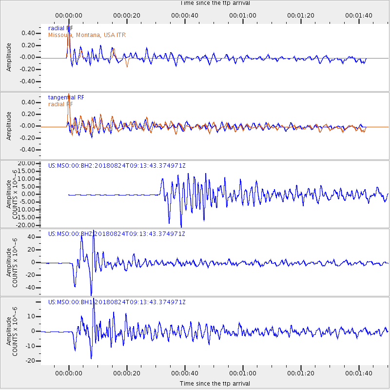
Signal To Noise
| Channel | StoN | STA | LTA |
| US:MSO:00:BHZ:20180824T09:13:43.374971Z | 221.83626 | 1.9240151E-5 | 8.673132E-8 |
| US:MSO:00:BH1:20180824T09:13:43.374971Z | 89.63164 | 5.2115206E-6 | 5.8143762E-8 |
| US:MSO:00:BH2:20180824T09:13:43.374971Z | 89.09833 | 6.21386E-6 | 6.974161E-8 |
| Arrivals |
| Ps | 2.0 SECOND |
| PpPs | 8.1 SECOND |
| PsPs/PpSs | 10 SECOND |


