You are here: Home > Network List > US - United States National Seismic Network Stations List
> Station NHSC New Hope, South Carolina, USA > Earthquake Result Viewer
NHSC New Hope, South Carolina, USA - Earthquake Result Viewer
| Earthquake location: |
Peru-Brazil Border Region |
| Earthquake latitude/longitude: |
-11.0/-70.8 |
| Earthquake time(UTC): |
2018/08/24 (236) 09:04:06 GMT |
| Earthquake Depth: |
609 km |
| Earthquake Magnitude: |
7.1 Mww |
| Earthquake Catalog/Contributor: |
NEIC PDE/us |
|
| Network: |
US United States National Seismic Network |
| Station: |
NHSC New Hope, South Carolina, USA |
| Lat/Lon: |
33.11 N/80.18 W |
| Elevation: |
11 m |
|
| Distance: |
44.8 deg |
| Az: |
348.829 deg |
| Baz: |
166.902 deg |
| Ray Param: |
0.068608716 |
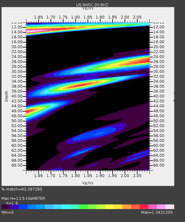
| Estimated Moho Depth: |
13.5 km |
| Estimated Crust Vp/Vs: |
1.60 |
| Assumed Crust Vp: |
6.565 km/s |
| Estimated Crust Vs: |
4.103 km/s |
| Estimated Crust Poisson's Ratio: |
0.18 |
|
| Radial Match: |
93.297295 % |
| Radial Bump: |
400 |
| Transverse Match: |
88.5083 % |
| Transverse Bump: |
400 |
| SOD ConfigId: |
2825771 |
| Insert Time: |
2018-09-07 09:21:11.084 +0000 |
| GWidth: |
2.5 |
| Max Bumps: |
400 |
| Tol: |
0.001 |
|
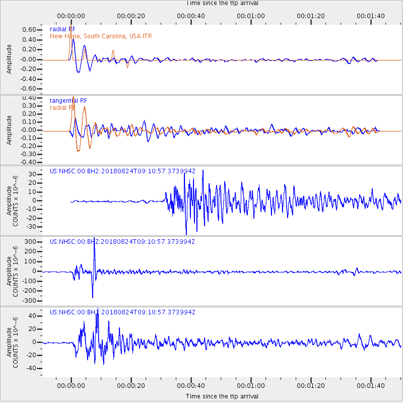
Signal To Noise
| Channel | StoN | STA | LTA |
| US:NHSC:00:BHZ:20180824T09:10:57.373994Z | 76.407814 | 3.456071E-5 | 4.5231909E-7 |
| US:NHSC:00:BH1:20180824T09:10:57.373994Z | 22.914928 | 1.1964947E-5 | 5.2214637E-7 |
| US:NHSC:00:BH2:20180824T09:10:57.373994Z | 11.66658 | 5.954324E-6 | 5.1037443E-7 |
| Arrivals |
| Ps | 1.3 SECOND |
| PpPs | 5.0 SECOND |
| PsPs/PpSs | 6.3 SECOND |


