You are here: Home > Network List > US - United States National Seismic Network Stations List
> Station WRAK Wrangell Island, Southeastern Alaska, Alaska, USA > Earthquake Result Viewer
WRAK Wrangell Island, Southeastern Alaska, Alaska, USA - Earthquake Result Viewer
| Earthquake location: |
Peru-Brazil Border Region |
| Earthquake latitude/longitude: |
-11.0/-70.8 |
| Earthquake time(UTC): |
2018/08/24 (236) 09:04:06 GMT |
| Earthquake Depth: |
609 km |
| Earthquake Magnitude: |
7.1 Mww |
| Earthquake Catalog/Contributor: |
NEIC PDE/us |
|
| Network: |
US United States National Seismic Network |
| Station: |
WRAK Wrangell Island, Southeastern Alaska, Alaska, USA |
| Lat/Lon: |
56.42 N/132.35 W |
| Elevation: |
81 m |
|
| Distance: |
84.2 deg |
| Az: |
330.591 deg |
| Baz: |
119.829 deg |
| Ray Param: |
0.043870654 |
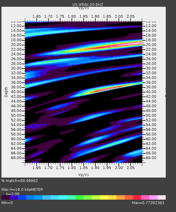
| Estimated Moho Depth: |
19.0 km |
| Estimated Crust Vp/Vs: |
2.09 |
| Assumed Crust Vp: |
6.597 km/s |
| Estimated Crust Vs: |
3.157 km/s |
| Estimated Crust Poisson's Ratio: |
0.35 |
|
| Radial Match: |
88.49882 % |
| Radial Bump: |
400 |
| Transverse Match: |
81.62508 % |
| Transverse Bump: |
400 |
| SOD ConfigId: |
2825771 |
| Insert Time: |
2018-09-07 09:21:32.107 +0000 |
| GWidth: |
2.5 |
| Max Bumps: |
400 |
| Tol: |
0.001 |
|

Signal To Noise
| Channel | StoN | STA | LTA |
| US:WRAK:00:BHZ:20180824T09:15:03.80002Z | 125.08995 | 1.280074E-5 | 1.0233228E-7 |
| US:WRAK:00:BH1:20180824T09:15:03.80002Z | 14.621313 | 2.1583317E-6 | 1.4761544E-7 |
| US:WRAK:00:BH2:20180824T09:15:03.80002Z | 45.409527 | 3.814956E-6 | 8.4012235E-8 |
| Arrivals |
| Ps | 3.2 SECOND |
| PpPs | 8.7 SECOND |
| PsPs/PpSs | 12 SECOND |


