You are here: Home > Network List > XI95 - Saudi Arabia Broadband Array Stations List
> Station HALM XI.HALM > Earthquake Result Viewer
HALM XI.HALM - Earthquake Result Viewer
| Earthquake location: |
Kuril Islands |
| Earthquake latitude/longitude: |
44.5/149.4 |
| Earthquake time(UTC): |
1996/01/31 (031) 20:30:47 GMT |
| Earthquake Depth: |
58 km |
| Earthquake Magnitude: |
5.8 MB, 6.1 UNKNOWN, 5.9 MW |
| Earthquake Catalog/Contributor: |
WHDF/NEIC |
|
| Network: |
XI Saudi Arabia Broadband Array |
| Station: |
HALM XI.HALM |
| Lat/Lon: |
22.85 N/44.32 E |
| Elevation: |
930 m |
|
| Distance: |
84.4 deg |
| Az: |
296.476 deg |
| Baz: |
44.019 deg |
| Ray Param: |
0.045413837 |
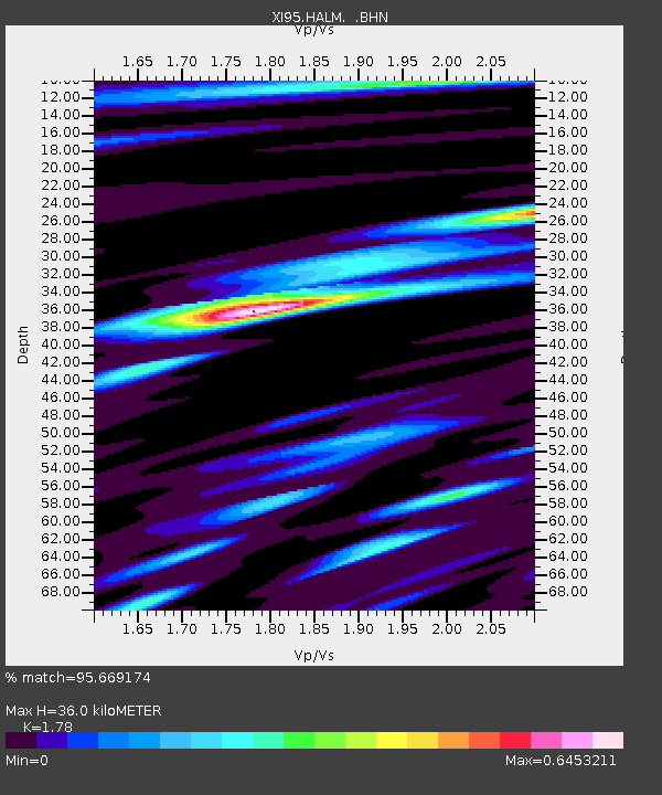
| Estimated Moho Depth: |
36.0 km |
| Estimated Crust Vp/Vs: |
1.78 |
| Assumed Crust Vp: |
6.498 km/s |
| Estimated Crust Vs: |
3.65 km/s |
| Estimated Crust Poisson's Ratio: |
0.27 |
|
| Radial Match: |
95.669174 % |
| Radial Bump: |
318 |
| Transverse Match: |
81.50617 % |
| Transverse Bump: |
400 |
| SOD ConfigId: |
6273 |
| Insert Time: |
2010-03-09 23:36:05.987 +0000 |
| GWidth: |
2.5 |
| Max Bumps: |
400 |
| Tol: |
0.001 |
|

Signal To Noise
| Channel | StoN | STA | LTA |
| XI:HALM: :BHN:19960131T20:42:41.903015Z | 4.2117486 | 1.6391496E-8 | 3.891851E-9 |
| XI:HALM: :BHE:19960131T20:42:41.903015Z | 2.4481757 | 1.338923E-8 | 5.4690643E-9 |
| XI:HALM: :BHZ:19960131T20:42:41.903015Z | 6.799485 | 5.8181275E-8 | 8.556718E-9 |
| Arrivals |
| Ps | 4.4 SECOND |
| PpPs | 15 SECOND |
| PsPs/PpSs | 19 SECOND |


