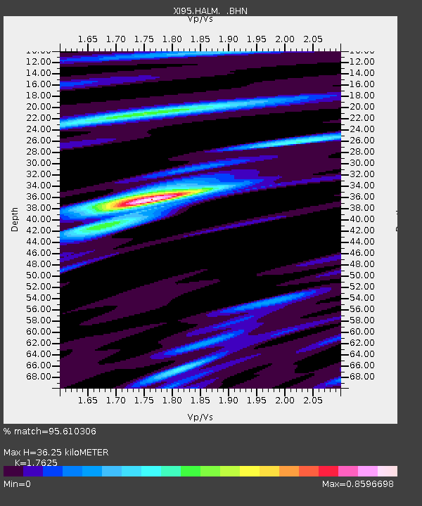
HALM XI.HALM - Earthquake Result Viewer

Earthquake location: Northern Molucca Sea
Earthquake latitude/longitude: 1.6/126.6
Earthquake time(UTC): 1996/05/07 (128) 08:44:36 GMT
Earthquake Depth: 33 km
Earthquake Magnitude: 5.9 MB, 5.9 MS, 6.0 UNKNOWN, 5.9 MW
Earthquake Catalog/Contributor: WHDF/NEIC
Network: XI Saudi Arabia Broadband Array
Station: HALM XI.HALM
Lat/Lon: 22.85 N/44.32 E
Elevation: 930 m
Distance: 82.2 deg
Az: 292.702 deg
Baz: 91.514 deg
Ray Param: 0.046993375
Estimated Moho Depth: 36.25 km
Estimated Crust Vp/Vs: 1.76
Assumed Crust Vp: 6.498 km/s
Estimated Crust Vs: 3.687 km/s
Estimated Crust Poisson's Ratio: 0.26
Radial Match: 95.610306 %
Radial Bump: 400
Transverse Match: 48.106873 %
Transverse Bump: 400
SOD ConfigId: 6273
Insert Time: 2010-03-09 23:36:35.529 +0000
GWidth: 2.5
Max Bumps: 400
Tol: 0.001

Signal To Noise

ChannelStoNSTALTA
XI:HALM: :BHN:19960507T08:56:23.274011Z0.953781559.0527344E-89.491412E-8
XI:HALM: :BHE:19960507T08:56:23.274011Z10.2233622.2337481E-72.1849447E-8
XI:HALM: :BHZ:19960507T08:56:23.274011Z10.6209875.817218E-75.477097E-8
Arrivals
Ps4.4 SECOND
PpPs15 SECOND
PsPs/PpSs19 SECOND